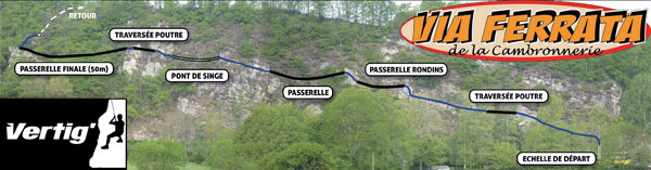
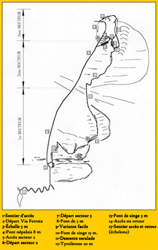
Via Ferrata La Chal, St-Colomban, Savoie


    Footbridge    Monkey Bridge    Ladder      Zipline  
1 x 21m 2 0 0


Features

Extraordinary route, a rope bridge, footbridges, and vertigo. This via has it all. A real delight. Fun.

Beginner's route at the beginning for children...

South facing, you can go up it most of the year.


ViaFerrata Tips and Tricks

Whatever you do, don't miss this via ferrata, it is simply fantastic.

A learner's via ferrata allows you to teach your children (7 years and older) and beginners in complete tranquility. Access to both itineraries is free.


Grade

 Strength  2
 Dizziness  4
 Type    Mountain: 2  
 Technics  2
 Evaluation     Difficult


Information

St-Colomban Tourism Office


Length and Altitude

Length: 400 m.
Elevation gain : 216 m
Start : 702 m
Finish : 918 m
Exposure : Southeast facing


Time of Year

Almost all year except when snow makes an appearance.


Timing

ViaFerrata access: 10 minutes
Via Ferrata: 2h
Introduction for children : Between 20 minutes and infinity for children
Way back: 30  minutes


By Car

Chambéry, towards Modane, St-Jean de Maurienne. Before St-Jean go right towards St-Colomban.


By Train or Bus

Check with the SNCF: schedules and fares.


Access

Cross the village of St-Colomban, you'll find the via ferrata by the exit to the right of the road. It is well signed.


Via Ferrata

This Ferrata is a bit of an original chef d'oeuvre.

You won't get bored, 1 footbridge, 2 rope bridges, the sensation of the void... everything is in place for your moment of pure pleasure.
The trickiest section is near the beginning, so you'll be caught. The first escape route is found after the footbridge. Next you go on a long and very aerial traverse with two rope bridges.

A few steep and athletic sections near the end offer themselves freely to your tired arms, who, by this point, are not asking for so much!


Way Back

Intuitive.

Where to Spend the Night

Check with the tourism office.


Media


by DavidZof


Via Ferrata des Rochers de la Cambronnerie, Clécy, Calvados

     Footbridge     Monkey Bridge    Ladder      Zipline   
1 x 50m 1 x 14m 0 0


Features

Lots of fun, has a beam, bridge, and footbridge. This via ferrata is perfect for families and kids who are not too scared of a little void. There is a rope bridge facing the river and a 50m footbridge at the end of the route. Short, but nice.

It is possible to go on a zipline which is not linked to the via ferrata

You'll finish your outing by taking the Croix de la Faverie trail.

You have to pay. Have a bit more than 15 euros to include rental costs. Minors under 16 years of age must be accompanied by an adult. For those who are 16 or older, a parental authorisation is necessary. One should not ignore the regulations, especially when a via ferrata is not free!


ViaFerrata Tips and Tricks

If you like ziplines, this one is worth gold!

Before going, make sure it's open.

There are other outdoor activities, like canoeing, in the park. A day full of adventure.


Grade

 Strength  1
 Dizziness  2
 Type    Plain: 2    
 Technics  2
 Evaluation Easy


Information

Suisse-Normande Tourism Office

Vertig Sport is the owner of this area and you must pay the entrance fee here.


Length and Altitude

Length : 250 m
Elevation gain: 70 m
Maximum vertigo: 50 m (which already fairly impressive)


GPS Coordinates

48°54’43.17’’N    
0°28’33.93’’O


Time of Year

April to May + September
- weekends and holidays from 10h to 18h.


July and August, every day from 10h to 18h.

Upon reservation for the rest of the year.


Timing

Access: 1 minute
Via ferrata: 45 min - 1h
Way back: 15 minutes


By Car

South of Caen on D562 until you reach Clécy


By Train or Bus

Check with the SNCF: schedules and fares.


Access

The via ferrata is located on the banks of the Orne river in the hamlet of La Cambronnerie. See the map above.


Via Ferrata

You will cross the rocky slopes with the most spectacular cliff itinerary that includes a series of alternating beams and footbridges.

The via is not very difficult and a lot of fun and you will be overlooking the flowing Orne beneath you! It is equipped just as needed and there is little contact with the rock.

It starts off with a 20m climb to gain some altitude and then you set out on a traverse.


Way Back

You're back to the parking lot in 10 minutes


Where to Sleep

Check with the tourism office at the via ferrata entrance, they know some places


Media

Via Ferrata de l'Aiguillette du Lauzet, Le Monêtier les Bains, Hautes Alpes


   Passerelle       Pont de bois       Echelle      Tyrolienne  
0 0 1 0
  

Caractéristiques

Une belle randonnée verticale qui remplit la journée, permet de s’offrir un sommet élégant à 2600m. Pas mal de marche dans un chemin ferré.

Ambiance haute-montagne.


Conseils ViaFerrata

La descente  s'effectue dans un véritable HLM à marmottes, à tes sifflets...  En fin de saison, les dites marmottes sont nettement plus grasses et lentes dans les déplacements. C'est une bonne époque pour les observer. Mais ne cours pas après... elles ont besoin de toutes leurs calories pour passer l'hiver.

Prends ton appareil photos car du sommet, ça vaut la peine.

Ne la faire que par beau temps car le coup d'oeil du sommet, c'est le su-sucre!


Cotation

 Physique 2
 Gaz 2
 Type Haute-Montagne: 3
 Technique   1
 Evaluation    Peu Difficile


Information

Office du tourisme de Serre Chevalier
Ils ne se sont pas foulés pour mentionner leur via sur leur site mais au moins tu as le contact!


Longueur et Altitude

Départ 1’710 m
Arrivée 2'600m
Dénivelé 900 m
Longueur : 500 m


Coordonnée GPS


Période

Juin - Octobre (attention à la neige et en début de saison à cause du dégât causé par l'hiver)


Horaire

Accès: 45 minutes
Viaferrata : 3-5 heure.
Retour : 1h30 par un sentier balisé orienté Est au départ.


Par la route

Sur la route de La Grave / Serre-Chevalier, parque sur le parking du départ de la ViaFerrata au Lauzet à Monêtier-les-Bains.


Par le Train ou le Bus

Voir avec la SNCF: horaires et tarifs.


Accès

Du parking du Pont de l’Alpe, prends la piste de l'Alpe du Lauzet qui monte au Col du Chardonnet. Après env. 40 m de marche, tu arrives à un petit village (altitude 1'940 m) et prends à droite (en direction des cairns). Une inscription t'indique le départ le la via ferrata


Via Ferrata

La via ferrata débute sur un sentier avec des vires assez raides dans l’herbe. Tu traverses ensuite une dalle et une échelle.

Tu continues par une faille assez étroite, obscure et sombre (et Isabelle a les yeux bleus). Tu es dans la boîte à lettres.
Tu remontes de nouvelles dalles qui vont déboucher sur un chemin de cailloux qui te mène au sommet perché à 2'610 m.

De là, tu as une splendide vue sur le Massif des Ecrins, le Queyras, le Mont Viso, les Agneaux et le Briançonnais


Retour

Le retour s’effectue sur l’autre versant (est).

Après un départ un peu sportif et étroit, tu découvres un bon sentier qui te ramène au pied de l'Aiguillette sur le GR 50. Tu rejoins le plateau de Pervous (2'340m) ainsi que les chalets de l’Alpe du Lauzet un chouilla plus bas


Où dormir

Voir avec l'Office du Tourisme


vidéo par Jasmienes, Youtube


Photos


Via Ferrata Comtes Lascaris, Tende, Alpes Maritimes


     Footbridge     Monkey Bridges     Ladder      Ziplines  
0 2 0 2


Features

A demanding via ferrata that will take you back in time with the the ruins of the Lascaris counts' medieval castle, the Cave of the Heretics and the Saint-Sauveur Chapel (Saint Savior). 

Hanging bridge, swinging bridge and ziplines of over 100m are accessible, 3h30 hours for the more technical part or 2h for the castle part.

Just above the village.

Children under 12 are not allowed on.

Price: 3.5 Euro


ViaFerrata Tips and Tricks

To see in the region: La Vallée des Merveilles (The Valley of Wonders), which has the biggest site of open air rock engravings in Europe.

You can rent equipment at both of the stores in Tende. If you are going to the Brigue Via Ferrata (which is nearby) rent your equipment in Tende as it is not possible to rent equipment in Brigue.


Grade: Voie des Hérétiques

 Strength  4 
 Dizziness  3
 Type  Mountain: 2
 Technics  3
 Evaluation  Very Difficult


Information

Tende Tourism Office


Length and Altitude

Start: 850 meters
End: 1,150 meters
Length: 1,000 meters
Elevation gain: 300 meters


Time of Year

Closed during the winter months


Timing

Château (Castle) Route
Access: 10 minutes
Via ferrata : 1h15 minutes.
Way back: 30 min


Hérétiques (Heretics) Route:
Access: 10 min
Via ferrata: 2h30 minutes
Way back: 45 minutes


By Car

58km north of Menton and it winds and turns and winds. It's after the Gorges de Bergues and St-Dalmas-de-Tende (from here you can go the Vallée des Merveilles).

Tende, the highest village in the Roya valley is 9km away from the etrance of the Tende tunnel under the Tende pass (italian border).


By Train or Bus

From Nice towards Cuneo. Check with the SNCF: schedules and fares.


Access

The markings start from the parking lot at the Tende SNCF station. Via the "Rue de France" ("Road of France") you go up into the old city, then you tick-tock at the base of the "Tour de l'Horloge" ("Clock Tower") while you cross the cemetary...The path goes up above the village on the rocks of the  west slope of St-Sauveur.L


Via Ferrata

It starts off tough and with a fairly long hanging bridge! It's better if you already have a lot of via ferrata experience!

The climb is easy and there is quite a lot of contact with the rock. A footbridge brings you over a deep gap to get to the St.Sauveur Chapel where you will get onto a long zipline.

Grotte des Hérétiques: Things get more intense and the itinerary goes up the rock face progressively. It is impossible to go back at this point. You must keep going steadily, step by step (and the steps are far apart so take big strides- this is why children under 12 are not allowed on this via)

The via ferrata ends with the zipline.


Way Back

Pas moyen de te tromper et compte 45 minutes depuis le sommet.

Where to Spend the Night

Check with the Tourism Office. It is well worth it to spend a night here as the village is very nice.


Media

vidéo par ViaFerrata.com  One Minute Ferrata, Youtube


Via Ferrata Dia Manicella, Moltifao, Corsica

     Footbridge     Monkey Bridge    Ladder      Ziplines  
0 0 0 7


Features

You are no longer allowed onto this via ferrata with your own equipment. For this reason, all the equipment has to be rented from the owner of the via ferrata: In Terra Corsa or Business is Business: +25 euros for 4h, +30 euros for the whole day with the option of doing two other via ferratas and 2 ziplines in the same area.

The surroundings are incredible, but the via ferrata was overly-cabled and there are escape routes all over the place. Two other via ferrats are located in this amusement park. The Manicella is the hardest of the three.


ViaFerrata Tips and Tricks

There is a start every hour. Call before so that you're not champing at the bit.
Crowded during the summer.


Cotation

 Strength 2
 Dizziness 2
 Type Plaine: 1
 Technics   3
 Evaluation Difficult


Information

The owner of the via ferrata: In Terra Corsa 


Length and Altitude

Length 350m
Elevation gain: 200 m
Start :  340 meters
End :  540 meters


Time of Year

All year long


Timing

Getting the equipment, following the instructions the man gives you at the entrance, going to the cash register: 1h
Approach : 10 minutes
ViaFerrata : 2 to 3 hours


By Car

From Ponte-Leccia, take N197 towards Calvi and then it splits off about 2km further onto the D47 (which then becomes the D147) going towards Asco.


By Train or Bus

Check with the SNCF


Access

There is a In Terra Corsa adventure park. Normally there will already be some people when you arrive. Then you can let yourself be guided.


Via Ferrata

After several meters of ascent, squirm your way through the window, a small opening in the rock that will lead you to the "stretta di ventu" (wind draft). Wow there, more cable, but don't worry, it's so you can better admire the landscape.

You will then continue the progresson with a visit of the cave and the tower. A 7m footbridge will lead you across a chimney and then you will slide into the word of the tafoni, a result of erosion and a phenomenon that is particular to "l'Ile de Beauté" ("The Island of Beauty", another name for Corsica).

A few meters further and you will come to the Inclinatu (the overhang) and 200m of void. Very vertiginous and very tough on the arms... But wholly composed of beauty once you get to us passu (the passtime)... a superb hanging garden...a little break and then you go up between the rock faces and the void to the 540m Mont Al Lardo.
(Description: Gérard Papandréou)


Way Back

Something particular about this via ferrata is that after having climbed up the mountain, it is possible to go back down with 7 ziplines, up to 220 meters of zipline to go back to the valley!


Where to Spend the Night

Check with the Motifao Tourism Office


Media

Via Ferrata Le Rocher Blanc, Serre Chevalier, Saint Chaffrey, Hautes-Alpes


     Footbridge     Monkey Bridge    Ladder      Zipline   
0 0 0 0


Features

2 easy via ferratas side by side. They are accessible via the lifts! You can go up on foot, but it will take you 4 hours to get to the via ferrata.


ViaFerrata Tips and Tricks

Be careful of falling rocks and contact the station to see if the lifts are open.

You are in a mountain environment: make sure you bring proper hiking shoes, good sunglasses, sunscreen, a waterproof jacket that will keep you warm if it rains, and something to munch on if you get hungry. Just let Kilian Jorent go in his running shoes and shorts!

If you are a fan of MTB, you can take your bike and come back down on two wheels. It's really nice.


Grade

 Strength  Via left:  2
 Via right:  1
 Dizziness  Via left:  2
 Via right:  1
 Type      High-Mountain: 1
 Technics         Via left:  1
 Via right:  1
 Evaluation  Via left:  Difficult
 Via right: mid-Difficult


Information

Via Ferrata Le Rocher Blanc, Serre Chevalier, Saint Chaffrey, Hautes-Alpes


Length & Altitudes

Start : 2,370 m
Elevation gain: 105 m
Summit: 2,475 m


Time of Year

End of June/beginning of July to end of August with the possibility of taking the lifts.


Timing

Approach, without taking the lifts: 4h
Approach, with lifts: 20 min
Via ferrata : 1h30 - 2h00
Way Back : 30 min


By Car

Towards Serre-Chavalier. La via ferrata is found in the communce of ST-Chaffrey, near the base of the lifts.

You can also leave from Briançon but you will have to walk 1h30 to get to the via from the top of the Prorel lifts.


By Train

Check with the S.N.C.F .


Access

 The lifts leave about every 15 minutes and go up to 2,480m.

At the top of the lifts you go down the ridge on the left until you reach the pass. Then you scramble towards the Rocher Blanc. Once  you see the sign for the via ferrata you are there. If you have the coice start with the harder of the two (if you came to do both).

You can also take the Prorel lifts in Briançon, but it will be1h30 of approach.


Via Ferrata 

You have the choice between two via ferratas. The one on the left is steeper and more vertiginous, but very well equipped.
The one on the right is a bit easier and not as steep.

If you leave early enough you can do both via ferratas in the same day.

The climbs are on steep walls, but they are short and then you get to a rocky arrête. From the summit you have a magnificent view. You will certainly notice the pink limestone and sandstone!


Way Back

30 minutes to the lifts.


Where to Spend the Night

Check with the Tourism Office


Media

par Chaîne de zebrprod, Youtube

30e Via Ferrata Rocher du Bez, Serre Chevalier, Hautes Alpes, France

Via Ferrata Rocher du Bez, Serre Chevalier, Hautes Alpes


     Footbridge     Monkey Bridge    Ladder      Zipline   
0 0 0 0


Features

For first-timers and children. In one part of the via ferrata the rungs are purposefully closer together for children.

You will find two via ferratas. "L'Ancienne" ("The Ancient") is easy and in two parts with a "crevasse" section in the middle of the cliff.


ViaFerrata Tips and Tricks

At the beginning of the season, check to see if the road is accessible for cars. Sometimes it is flooded with water.


Grade

 Strength 1
 Dizziness 1
 Type High Mountain: 2
 Technics   1
 Evaluation Easy


Information

Serre Chevalier Tourism Office


Length and Altitude

Start : 1,620 m
End : 1,720
Elevation gain : 100m
Length : 350 m


Time of Year

Check with the tourism office.


Timing

Approach : 20 min
Via ferrata : 1h00
Way back : 20 min


By Car

Go past Serre-Chavalier. La via ferrata is found in the commune of Villeneuve la Salle


By Train or Bus

Check with the SNCF.  schedules and fares


Access

Dans la commune de Villeneuve la Salle, tu vas suivre la rivière jusqu'au parking du Parc Aventure. Tu continues pour te parquer 200m plus haut.
Le panneau de la via ferrata est sur ta droite.


Via Ferrata

This via ferrata is made up of 2 parts or 2 via ferratas, whichever you prefer.

The first one is very easy for children or beginners and you will pass through the guts of the cliff.

The second one starts to the left of the climbing rock. It is a bit more vertiginous, but it is accessible for all.


Way Back

The approach walk and the way back can both seem long.


Where to Spend the Night

Check with the Tourism Office


Media

vidéo par David Cracou, Youtube


Via Ferrata de Peille, Peille, Alpes Maritimes


     Footbridge     Monkey Bridge     Net       Zipline   
2 2 2 2


Features

4 very different sections, and there is an escape possible before each: Hanging bridge, footbridge, a net over the void, technical parts, vertigo, and best of all an 80m zipline.

A beautiful via ferrata if you have mastered the technique and if you have experience.

You have to pay: 3 Euro for each adult, but it worths it.

It's also possible to do it at night. There are reserved nights.


ViaFerrata Tips and Tricks

Call before going as the number of participants is limited. You must reserve your seat!

Leave early in the morning...the traffic is as bad as in Los Angeles, minus the exhaust gas, at least that...

If the first part is too crowded you can start near the road for the second demanding part, but it's a shame to have come all this way to miss the first part.

Bring water. Full exposure to the Provence sun.

Don't bring beginners as it is not a via ferrata for first-timers. Some morons convince their friends to try this via ferrata as their first, but they are morons!
If you really want to do it as a first-timer, you can go with one of the available guides.


Grade

 Strength  4
 Dizziness  3
 Type  Plaine: 2
 Technics            3
 Evaluation     More than extreme   


Information

Peille Commune.

The Absinthe bar is the owner of the Via Ferrata, here you can find rental equipment and details and explanations and entrance tickets:Tél: 04 93 79 95 75
Outside of France  +33 4 93 79 95 75


Length and Altitude

Start: 515 meters
End: 700 meters
Length: 800 meters
Elevation gain: 185 meters


GPS Coordinates

N 43'48'268
E 007'24'225
Alt. 647 m.  


Time of Year

All year. But be careful during the winter, it is not open every day.

Some nighttime outings are organized, check for dates at the Absinthe bar.


Timing

Approach: 5 minutes
Viaferrata : 1h45 during the week and 10 to 18h on the weekends!
Way Back: 15 minutes on an excellent trail


By Car

We'll be nice and give you a tip. Instead of going around in circles like we did trying to find one of the three routes that leads to Peille,
Exit the Nice-Est highway at Exit 57, La Turbie
In La Turbie get on the deparment road (route départementale) 53 to get to Peille.
Menton 24 km
Monaco 15 km
Vintimille 35 km.


By Train or Bus

From Nice with the bus and a lot of time to spare.  Check with the SNCF: schedules and fares.


Access

In Peille, park in one of the public village parking lots made for those going up the via ferrata. Then cross the village to get your ticket at the bar and to get to the start of the via ferrata which is at the bottom of the village.


Via Ferrata

Le Baous de Caster: It starts off with a footbridge 30 pitiful meters above the ground. Then the proper via ferrata thrills begin with a first slab where an overhang might get you stuck. 300m of void. and behind you, before you transition onto a footbridge on the opposite wall, direct sunlight. If you don't want to cross this, there is an escape route...

Second section : It is strenuous and there are a lot of overhangs. The cherry on the cake is a hanging bridge with a magnificent view of the Peille village. A photo break is mandatory...

In the most eastern cave you can choose to keep going on to the next two parts or finish your adventure here. You can go on the infamous net or you can avoid it, but if you avoid it you still have to climb up!
At the top of the net you can zip off to the right to get on the easy variant or throw yourself into the Overhang of Justice. This section is reserved for skilled ferrata-ists and those who have strong arms. It need not be said that this is the thrilling section, even chilling.
Just above this variant you come to section that is not equipped with footholds, so it's all arm strength...or technique if you're holding us.

After that hard part: the Zipline. Be careful for the Zipline section! There is a mattress at the end of the zipline. It is there to save your life or a leg in case you need it! Do not use the Speed pulley from Petzl...if you don't weigh much, let yourself go. However, if you are heavier (90kg or more) brake because you might just end up testing the theory of the heavy thing against the insufficiently stuffed mattress..


Way Back

The way down towards the via ferrata... a real delight on a little shaded trail with a nice view on the cemetery.


Where to Spend the Night

There are several options in the village.


Media

vidéo by Via Ferrata.com, Youtube


Via Ferrata Prise de la Bastille, Grenoble, Isère


      Footbridge     Monkey Bridge    Ladder      Zipline   
1 1 0 0


Features

A stone's throw away from the city center.

In two parts. The second part is reserved for well trained via ferrata-ists. Oh boy! It's tough...

With 1 rope bridge and 1 footbridge


ViaFerrata Tips and Tricks

For additional information contact the Bureau Information Montagne (Mountain Information Desk) located on the 1st floor of the Grenoble Tourism Office, they can also give you information for other mountain activities: hiking, MTB, climbing, white-water, mountaineering. 


Grade

 Strength  Part 1
 Part 2
2
4
 Dizziness  Part 1
 Part 2
 2
 3
 Type   Part 1
  Part 2
Plaine: 1
 Technics   Part 1
  Part 2
2
 Evaluation   Part 1
  Part 2
 Difficult
 Extreme


Information

Grenoble Tourism Office


Length and Altitude

First part

Elevation gain : 120 m
Length : 250 m
Altitude at the start : 220 m

Second part

Elevation gain : 110 m
Length: 300 m 
Altitude at the End : 450 m


Time of Year

All year long except when the soft snow adorns the mountains in white


Horaire

Access : to have plenty of leeway:  a full minute
Via Ferrata 1 : 45 minutes
Via Ferrata 2 : 45 minutes
Way back : 30 minutes


By Car

When arriving in Grenoble from highway A48 take the "Bastille" exit which is located at the "Porte de France" and the Esplanade parking lot will be on your left.

Leave your car in the Esplanade parking lot which is located at the entrance to Grenoble. Lock your doors and don't leave anything on the seats.

By Train or Bus

For once you don't have an excuse to not take the train: Stop: Grenoble Train Station. Check with the SNCF: schedules and fares.


Access

From the Train Station

Directly across from the station exit go towards the Casimir Périer street and keep going to the Place Hubert Dubedout. From here, cross the Isère river on the Pont de la Porte de France and you will arrive at the Porte de France (a kind of mini Arc de Triomphe).

The starting point is at number 22 Route de Lyon, 100m from the Porte de France behind the Esplanade parking lot. In front of you you will be able to admire the old Vicat quarry. The gate is open from 9 a.m. to 8 p.m., the latest recommended start time is 4 p.m.


Via Ferrata

The Prise de la Bastille via ferrata is made up of two parts.

The first part,
With a grade rating of difficult - you start off by climbing up a pillar and then traversing the entire Vicat Cirque,  which includes a rope bridge and two footbridges. A beautiful view on the city of Grenoble.

Part 2
To get to the second part take a trail through the Guy Pape Park which will lead you to the foot of the second section in 15 minutes (there are signs along the trail).

The second part is essentially an ascending traverse of an overhang, it's really strenuous and there is no where to rest. Two escape routes were put in place to allow those who are worn out to still make it to the summit. It's tough stuff, and it is for you, friend with experience and strength.

Once the second part is finished you go over another small projection which is followed by 150m of steps that lead you to the ancient fortifications of the Bastille.

Here, take a picture and post it on social media for all your friends to see, and don't forget to add: "I did it!"!


Way Back

To go back down there are two options: Either go up 15 minutes to the top of the Bastille Fort and then use the lifts to get back to the city center, or take the Jardins des Dauphins path which will lead you to Porte de France in 20 minutes.
 

Where to Spend the Night

It's a big city, you'll be able to find something nice.


Media

vidéo par FH Sport, Youtube


Via Ferrata Nant de Rossane, Les Aillons, Savoie

     Footbridges      Monkey Bridge
Nepal Bridge
  Ladder      Zipline   
2 1
2
1 1 x 20m


Features

3 different parts with a zipline that you can bypass.
Great for an introduction to via ferrata with children or beginners


ViaFerrata Tips and Tricks

The zipline is not equipped... bring your own equipment. The rock is friable, wearing a helmet is mandatory (as it is, in fact, for all via ferratas). Bring your gloves, as always in the case of rock fall.


Grade

 Strength  1 secteur
 2 secteur
 3 secteur
 2
 1
 2
 Dizziness  1 secteur
  2 secteur
  3 secteur
1
1
2
 Type  1 secteur
 2 secteur
 3 secteur
 Mountain: 1
 Technics  1 secteur
 2 secteur
 3 secteur

2
2
2

 Evaluation  1 secteur
 2 secteur
 3 secteur
 Mid-Difficult
 Initiation
 Difficult


Information

 Aillons Tourism Office


Length and Altitudes

Length: 270 m.
Part 1: 100 m.
Part 2: 80 m.
Part 3: 90 m.

ViaFerrata Start:  1,050 meters
ViaFerrata End :  1,100 meters
Elevation gain : 50 m


Time of Year

As soon as their is now more snow. Check with the tourism office.


Timing

Approach: 10 minutes
Ferrata: 90 minutes
Way Back: 10 minutes


By Car

25 km from Chambéry, follow the Bauges massif


By Train

Check with the SNCF for buses and trains.


Access

From the Prés Pass towards the station.
At the roundabout go left until you reach the parking lot across from the equestrian center.
You'll reach the Rossane cave in 10 minutes.


Via Ferrata 

1st part
The first part lets you learn how to use the lanyards as it has intermediary anchor points for extra security.
Fairy difficult - total length: 100m - 1 5m ladder - 1 8m hanging bridge.

2nd part
As you follow the small path you meet up with the second part which is characterized by horizontal progression over a series of ledges.
Easy - total length: 80m - 1 5m footbridge.

3rd part
When you are about to reach the 3rd part, the 2nd part gives you the option of an easier variant which goes up sideways on a little ramp at the end of the footbridge.
Before crossing the footbridge you can go directly to the 3rd part via a short overhanging climb and a horizontal traverse of a very steep section under the overhangs, and then by crossing a depression on a 15m rope bridge (2 cables).

There is a small 20m zipline at the end of the via ferrata (a pulley is mandatory).
Difficult - total length: 90m - 1 12m rope bridge - 1 20 zipline - 1 5m rope bridge.


Way back

Pretty intuitive. No need to draw a map.

Where to Spend the Night

Stopover lodge with 10 beds : contact the tourism office


Media


par mrViaFerrata  Youtube

Via Ferrata Planfoy, Planfoy, Loire


     Footbridge     Monkey Bridge       Ladder      Zipline    
2 1 0 1


Features

2 via ferratas: The Adult's Via Ferrata and the Children's Via Ferrata, "Les Pillots", which is intended for children 6-12 years old and at least 1m10 tall.

The commune has made this are a "center of vertical activities."
It's free so you can try the whole package of vertical outdoor activities: Adult's and Children's Via Ferrata, Zipline, Adult Mountain Route.


ViaFerrata Tips and Tricks

Bring your MTB and also go visit the Pilat regional park.

This via ferrata is free. If you need a guide, plenty are available, and if you need equipment you can rent it.


Adult's Via Ferrata Grade

 Strength 1
 Dizziness 2
 Type  Plaine: 1
 Technics  3
 Evaluation               Mid-difficult      


Information

Planfoy Tourism Office.


Length and Altitude

Via Ferrata Start: 660 m
Elevation gain: 235 m.
Cable length: 600 m.
Exposure: Southeast on gneiss rocks.


Time of Year

Open all year. You can't go on it at night when the route is icy or snowed over.


Timing

Elevation gain: 100 m.
Length: 600 m.
Start: 800 meters
End:  900 meters

The adult's via ferrata (600 m long) takes 3-4 hours round trip and the Children's Via Ferrata (250m long) takes 2 hours.


By Car

RN 82 from St-Etienne towards the République Pass and Annonay. 8km from St-Etienne.


By Train or Bus

Take the TGV to St-Etienne if they're not on strike. Check with the SNCF: schedules and fares.


Access

A 45 minutes approach from the village of Planfoy.

Drop your car off gently in the parking lot near the cemetery!
From Planfoy a "yellow and white" marked trail leads you to the via ferrata after 30 to 45 minutes of walking. Onwards to the "center of vertical activities."


Via Ferrata

The platform at the start of the Adult's via ferrata is the easiest way to get on, but for those who are "in a rush" there is an intermediary access point.

The beginning is in the forest, easy. Then a section that is a bit more technical and leads to a big, but easy climb, a little footbridge, and then it's down to the big 17m footbridge. Once you are on the other side there is a big, but nice climb all the way to the top of the via ferrata.

The Gouffre D'Enfer Valley (Hell's Abyss Valley) with its two stone dams and Roch Corbière climbing site is a superb setting.

On the Children's Via Ferrata: a 30m combination of gymnastic's apparatus, including a suspended net, small hops, a platform where you can rest, and swings. These have replaced the forest route which was originally installed in 2006. For children the via ferrata ends by going from tree to tree on footbridges.


Way Back

It's pretty easy to find your way.
 

Where to Spend the Night

Camping, lodge in St Genest Malifaux (4 km), and plenty of other options on site


Media

vidéo par alain c, Youtube


Via Ferrata du Dévoluy, Le Dévoluy, Hautes-Alpes


     Footbridge     Monkey Bridge    Ladder      Zipline   
1 x 50m 1 x 14 m 0 0


Features

Two via ferratas: Les Baumes and la Vertigo. These itineraries meet up on a footbridge.

Above the Souloise river, over 50 meters above, a rope bridge (the 14m long and I'm not even scared type) lets you go from one bank to the other

This via ferrata evokes two different kinds of feelings: the mountain spirit from the Baumes traverse and the spelunking one from the Vertigo route.


ViaFerrata Tips and Tricks

At the end of this via ferrata perade you will come across a rock climbing site in the Rif gorges as well as an introduction to canyoneering.

If you have time, go. It's always nice to discover new things.


Grade

 Strength

Beaumes
Vertigo

1
3
 Dizziness Beaumes
Vertigo
 2
 3
 Type Beaumes
Vertigo
 Montagne: 3
 Montagne: 2
 Technics Beaumes
Vertigo
 1
 3
Evaluation  Beaumes
 Vertigo
 Mid-Difficult
  Difficult


Information

Dévoluy Tourism Office


Length and Altitude

Les Baumes
Length : 560 m
Start : 1,120 m,
Elevation gain: 50 m

La Vertigo
Start: 1120 m,
Length: 980 m
End : 1,290 m
Elevation gain: 70 m.


GPS Coordinates

From the parking lot at the start : 44.696246,    5.935093


Time of Year

From the beginning of May to the first snowfall. Check with the Dévoluy Tourism Office


Timing

Access: 1 minute

Baumes traverse: 1h30 to 2h
Vertigo Route: 1h30 to 2h

Way back: 15 minutes


By Car

N 54 Grenoble - Gap. N85 Vizille la Mure Corps D66 Pont de Sautet D 537 St-Disdien en Dévoluy D117 Giers Courtil Pont du Giers


By Train

Check with the SNCF: schedules and fares. But it's a nightmare to get there! There are connections with coaches and for those who can afford it, taxis. But that costs a bit more.


Access

From the Via Ferrata parking lot, cross the bridge and once you are on the bank, take the little trail going up.


Via Ferrata

What's special about this via ferrata is that there is a small cave to crawl through on all fours...Make sure you don't bring a big backpack.

The first part resembles a mountain trail and goes along the gorges 50m above the river. It's a good place to start for beginners. But, be careful, la Vertigo, which is yet to come, is on another level.

So if you are a beginner do not get this first easy part confused with the next part which is more sketchy and more like a real via ferrata.

Hint: Wear proper shoes, especially for when it's wet.

Via Ferrata Vertigo

The start of this demanding via ferrata is located on the right bank below the parking lot. You keep going on the same rock face to pass under the road bridge. A rope bridge (3m) connects this section with the old route and the footbridge.

It is a bit more vertiginous than les Baumes, but perfectly equipped. You'll head out into the gorges with the beautiful sound of the flowing water. The view from the traverse of the gorges is magnificent.


Way Back

You can get back to the parking lot in 10 minutes


Where to Spend the Night

Fontenil lodge

The La Souloise à Saint Etienne en Dévoluy Inn is the closest available accomodation to the via ferrata and you can also rent equipment there.


Media

Via Ferrata Rocher Jaune / Tête au Chamois, Les Diablerets, Vaud


   Footbridge     Wood Bridge       Ladder          Zipline    
0 1 x 3m 0 0


Features

Established during the International Alpine Film Festival on the 10th of October 1999, this via ferrata is also known by the name of "Tête au Chamois." It is located next to the first stop of the telecabine.

Setting: Splendid high mountain, a precipitious itinerary that offers a wide variety of terrain, alternating between comfortable sections on fairly wide ledges and impressive sections on slabs resembling climbing


Via Ferrata Tips

You have to pay for the cable car.
For the brave: from the village its 3h50 of walking there and back. Or buy only the way there and you can enjoy the way down... The Diablerets is an ideal region for canyoneering and mountain biking.

You are in a high mountain setting: Don't forget to take an extra layer and a jacket. Temperatures, even in the summer, can be cold. Excellent hiking shoes are necessary. The ground is often wet and slippery.

Legend has it that the people of this region are very attached to their money. So if a coin falls from your pocket and does not land on the ground, remember this!


Grade

 Strength  4 
 Dizziness  4
 Type  High Mountain:  2     
 Technics        1
Evaluation   Very Difficult


Information

Tourism Office des Diablerets 024 492.33.58.   +41.24 492.33.58

Cabane des Diablerets


Length

Length: 800 m
Orientation: North (in the shade)

Start: 2'400m.
Finish: 2'450m


GPS Coordinates of the Starting Point

N 46’20.357
E 007’12.854
Altitude : 2’426 m


Time of Year

June-October


Timing

Approach from the cable car: 5 min.
Via ferrata 2h30,
Way back to the cable car : 15 minutes
Way back by foot, 1h30 2h00.


By Car

From Lausanne take the highway towards Valais (Martigny, Sion) and exit in Aigle.

In the middle of Aigle, at a roundabout on the left take the route du Pillon towards Les Diablrets, it is indicated.

From Valais, Chamonix or the Aosta valley, take the Martigny highway towards Monthey-Lausanne. Exit at Aigle.


By Train

Contact the SBB, for bus and train schedules and fares. Take the train to Aigle, the small train to Diablerets, then the bus for le Pillon


Access

Leave your car in the parking lot located at the base of the Diablerets glacier ski lifts.

By foot:
Several footpaths lead to the base of the glacier's cablecar, here is the shortest, but account for 1h40 of walking. From Corabs, take the Aigue-Noire trail, then the Cascade du Dar and Col du Pillon.

By cablecar:
Otherwise you can take the cablecar and the ferrata is located at the first stop, this is a faster, but more expensive option.

From the hut, take the trail that goes down on the right (follow the blue and white markings)

Via Ferrata

The Ferrata follows a vertiginous ledge that is more or les pronounced, sometimes interrupted for some meters, requiring traverses, descents or climbs up rungs or small steps. The surroundings are vertiginous.

You will go through a mini cave and the famous section with a small wooden beam. If you are lucky enough to be over 190cm tall: may the force be with you!

The end of the via takes place on a fairly demanding wall that climbs straight up and is well equipped but always has certain points of contact with the rock. This wall brings you to the end of the via.

Way Back

If you are on time, you will be able to take the cable car. If you are beat, stay at the hut.

Where to Spend the Night

You can find a camping and some nice rooms in guest houses in the Diablerets.
Diablerets Hut: 60 spots available 024/492 21 02. For  25.— Frs., you'll have a bed!


Photos

Via Ferrata Tour d'Aï, Leysin, Vaud


   Footbridges     Monkey Bridge       Ladder          Zipline    
2 0 0 0


Features

 Vertiginous with a superb panorama on Lake Geneva, the Valais Alps, and Mt-Blanc. A bit difficult for children and beginners.

Some steps are a bit high/too far for people of average height.


ViaFerrata Tips and Tricks

Take your mountain bike (MTB) with you or rent one there, for the way down to Leysin is very nice.

A picnic is a must. At the summit of the via ferrata you can enjoy the incredible panorama while you eat.

Parking. We already received some messages from the Tourism Office and some inhabitants of Leysin lamenting our rant about the fact that there are no free parking spaces for the users of the via ferrata.
Consequently, we are making an effort to commend this great initiative to welcome tourists to the station with a fine if they do not pay for their parking and we really think its super cool and nice that they put a free parking lot 4km away from there. It would have been totally stupid for them to offer a combined lift and parking ticket for the users of the via ferrata as we suggested.


Grade

 Strength  2
 Dizziness  2
 Type            High-Mountain:  1         
 Technics                1
 Evaluation  Difficule


Information

Office du Tourisme de Leysin

Lifts: Télé-Leysin.


Length and Altitude

Lenght 320 m.

Elevation Gain: 150 m.


Time of Year

End of May to mid-October. Check with the lifts for the official start of the season.
Not practicable in the winter.


Timing

Approach from the top of the lift: 45 minutes
Via Ferrata 1h00 à 1h30
Way down to the mountain pasture: 45 minutes
To the parking lot: 30 minutes with an MTB, and 1h30 by foot.


By Car

From Geneva, take the highway towards Lausanne and then Sion-Martigny. From Chamonix and Aosta take the highway towards Martigny-Suisse. In Martigny take the highway towards Lausanne-Geneva. Exit at Aigle (25km).

In Aigle take the N 11, towards Château d'Oex, les Diablerets, Leysin.


By Train

Prends le train jusqu'à Aigle et ensuite jusqu'à Leysin.
Take the train to Aigle and then to Leysin.
Contact the SBB, for train and bus schedules and fares.


Access

Take the Berneuse lift.

There are few indications and markings, so you must have faith. When you arrive at the summit of the lifts you will see the Kuklos rotating restaurant. Look towards the restaurant. A mountain with a cliff rises in the background to its right. This is where you will find the Tour D'Aï ferrata.

Go down the very steep trail that leads to some small houses and a charming lake. Once you are at the bottom, climb up the hill on the left following the cables and poles of the lift. You will find a little trail that will lead you to the start. (see the picture from the guide at the top of the page).


Via Ferrata

There are some difficult moves from the very beginning. If you get pass them... you should be fine for the rest. Otherwise, turn back now gringo!

A little traverse up and down... brings you to the foot of the chimney. You will have to get past it... it's a nice opportunity to play Santa Claus. We hope that after this you will realize how hard Santa really works and that this coming winter you will leave him some cookies by the chimney...

It's a bit overhanging at the end of the chimney, but only a bit, and you get to see the void all around you. You arrive tranquilly to the summit of this via. Just one more little section, great for photos. The summit of the via is almost a classic.

Once you arrive on the plateau, you can make the most of an unforgettable and splendid panorama.


Way Back

The way down is a bit athletic, around 40 minutes. Be careful, there have already been deaths.

Once you arrive at the lake, you can get your bikes (if you came with your MTBs)... and off you go, down either to Leysin or Aigle.

If you came by foot, the concept is the same, but the way down to Leysin is a bit longer.


Where to Spend the Night

Camping Semiramis: Tel: +41 24 494 11 48 .


Media

vidéo par ViaFerrata.com, Youtube


Via Ferrata Tichodrome Noiraigue, Val de Travers, Neuchâtel


   Footbridge      Monkey Bridge       Ladder          Zipline    
0 0 0 0


Features

Discover the Val-de-Travers from another perspective. Excellent vertiginous sensations.
It is closed annually from the 1st of January to the 1st of July so as to allow Peregrin Falcons, Kestrels, and Wallcreepers to nest in peace.

The entry and exit cables are removed each season, thus blocking access to the cliff.


ViaFerrata Tips and Tricks

This via is great for first timers and kids 10 or older, take your quickdraws as it is not equipped properly for you to secure your kids with a rope.

This area is rather humid. Good Vibram soles and hiking shoes are necessary. There is an antenna, go have a look at it to see the Neuchâtel lake.

A question for the champs:  Why is it called Tichodrome?
This is the French name for the bird that nests in these cliffs (Wallcreeper in English).


Grade

 Strength  1 
 Dizziness  2
 Type  Plain: 2 
 Technics  1 
 Evaluation            Beginner. Easy


Information

Tourisme Neuchâtelois Val-de-Travers.

Association: « Via ferrata et escalade sportive »
Centre sportif du Val-de-Travers:  www.centresportif-vdt.ch


Length and Altitude

Cable length : 550 meters, no exit possible
Elevation gain :  150 meters
Start elevation: 950m   
End elevation: 1150m


Time of Year

Open from the 1st of July to the 31st of December (due to the bird nesting regulations, the entry cables to the route are removed outside of these dates).


Timing

Approach: 5 min
ViaFerrata: 1h00
Way Back: 5 min


By Car

From Neuchâtel go towards Val-de-Travers, Peseux, Rochefort, Noiraigue, at the exit of the Clusette tunnel, go towards Ponts-de-Martel and you are there. Haut de la Côte parking.
From Chaux-de-Fonds, go towards Val-de-Travers, la Sagne, Brot-Dessus. Haut de la Côte parking.


By Train

Neuchâtel-Noiraigue (then on foot to the via, about 1h00)
Chaux-de-Fonds-Les Ponts-de-Martel (then on foot to the via 45 min.-1h00). Contact the SBB, for schedules and fares.


Access

On foot, you can get to the beginning of the Via Ferrata from the Ponts-de-Martel station (45 minutes), from the Noiraigue station (1 hour), or from the Haut de la Côte restaurant (10 minutes).

From the parking, go briefly along the ridge on a marked trail and then head right towards the asphalt road lower down. Cross this road and go through the forest until you get to the start.


Via Ferrata

A nice ledge above Noiraigue.

Michel Gentil and his association, "Via Ferrata et escalade sportive" dug into this rock over time to make a very enjoyable via ferrata out of this ledge. The equipment and information he used were very carefully chosen. There is only one section that could make those who are less brave shudder, an overhanging section.

Magnificent view on the Neuchâtel lake at the top of the via.

You start by crossing a rocky projection on the way up by passing on natural ledges. Easy sections alternate with vertiginous sections where the cable is not completely taught and you hang out over the void. A good dose of void stretches out below your feet at the Nest Overhang. The itinerary splits before the view point (1,119 m), but this view is absolutely worth the detour.


Way Back

You can either go left along the ridge on the higher altitude Jura trail towards the start (and return to the train station) or you can go on the forested ridge that overlooks the restaurant parking. It is well indicated.


Where to Spend the Night

All the information for where to spend the night,  to eat, to go on beautiful hikes, or to discover the Val-de-Travers region, its museums and its particularities, is available from the Neuchâtel Val-De-Travers Tourism.


Vidéo par AandG2009, Youtube

Media

Via Ferrata Voie Hohl, La Face, Moleson, FribourgFerrata Voie Hohl, La Face, Moleson, Fribourg


   Footbridge      Monkey Bridge       Ladder          Zipline    
0 0   0


Features

Splendid panorama, long, varied. Not for beginners even if the final exit was made easier. In fact, the last overhang, which hung over the rest of the via, was completely taken down because it had the tendancy of creating traffic jams because of those who overestimated their capacities.

Cost: 4 Frs.-- for adults, 2 Frs.-- for children.


ViaFerrata Tips and Tricks

Take a picnic with you. The panorama at the top of the via ferrata is truly something to be savoured and the restaurant accepts picknickers! (buy a drink... they are nice...).
The via is entirely in the shade. Take an extra layer in case it's cold...

The Moléson is a superb resort!!! After the via you can enjoy summer sledding,devalkarting, or grass-scootering.

The lifts are open at 9h00. Make sure they are open if you want to take the funicular to get to the via ferrata.

What to eat in this region: the double Gruyère cream with the Gruyère meringues.


Grade

 Strength   3
 Dizziness   2
 Type    High Mountain: 2   
 Technics      1
 Evaluation                      Very Difficult 


Information

Office du Tourisme de Moléson Gruyère.


Length and Altitude

Length: 1'310 m
Elevation gain: 372 mètres
Start Elevation: 1'630m


GPS Coordinates

N 46'33'363
E 007'33'363
Alt. 1'522 m.


Time of Year

April - November


Timing

Approach from the end of the funicular line: 20 minutes
Via Ferrata: 2h30
Way back: with the lifts from the summit of the Moléson. On foot, 1h30


By Car

A 12 Vevey - Fribourg-Berne, Highway exit: Bulle
At the highway exit, take the first exit of the roundabout (next to the gas station) towards Moléson-Gstaad
Then follow signs for "Le Moléson"


By the Train

Go to Bulle and then by bus or train to Gruyère.
From Montreux: Montbovon to the Gruyère train station, then by bus to Moléson-sur-Gruyères.

Contact the SBB, for schedules and fares.


Access

Its very easy. At Moléson, park near the start of the Funicular.

From the Moléson-sur-Gruyères parking, go towards Plan-Francey on foot (1h15) or with the funicular (7 min, leaves every 20 min, at...h00,...h20,... h40). (14 Frs.-- there/back)

In Plan Francey you can rent via ferrata equipment.

From Plan-Francey follow the Via Ferrata signs for about 20 min and you will reach the base of the rock face. The route is in the rock face on the right, and not the via ferrata that is found on the ridge on the left.


Via Ferrata

The Via Ferrata traverses the north face of the Moléson, passing by the cross of the Petit Moléson and arriving at the summit of.... try to guess: the Moléson.

This is not a via ferrata for beginners and we always find some fools stuck on the way. Mountains are something to be respected!

The start is fairly simple, and makes for a great warm up. You climb in some beautiful chimneys that are sometimes a bit athletic. The route was wonderfully traced.

You are given the pleasure of a few overhanging sections... and they are a tad bit strenuous. These sections are not very long... and there are always some flatter areas nearby to rest. The closer you get to the summit, the more strenuous it is. A very nice climb in a chimney with a section that works the arms and is a bit more demanding.

The last part is absolutely amazing. Since there were too many fools who came to this via ferrata for an introduction and ended up getting stuck, the last overhang was removed.

The via is really well equipped. At times there is even a bit too much equipment, but you have the opportunity to be in contact with the rock. It's very enjoyable.

For taller people (like the guy writing this right now) its a bit complicated since you are often in overhanging sections.


Way Back

From the summit, you can go down on foot via Tsuatsaux (2h30 to the parking), via the Gros-Plané (1h45 to the parking) or with the cablecar (4 min to the upper train station).

Where to Spend the Night

Contacte the Tourism Office. The Moléson is a really nice resort.


Media


Olivier Buchs Youtube

Via Ferrata Loèche, Loèche, Valais


   Footbridge     Monkey Bridge    Ladders     Zipline  
1 0 +10 0


Features

The longest via ferrata in Switzerland (time)

There are two ferratas to choose from:
- Mieläs-Loèche les Bains, the easiest, with 5 ladders
-Daubenhorn, with an incalculable number of ladders and 6 hours worth of via ferrata.


ViaFerrata Tips and Tricks

The probability of receiving a pebble on your head is as high as the expensive cost of the obligatory parking lots in Loèche.

The traditional metal steps in the rock were replaced by some stakes, some nails. If you fall it hurts and you can be skewered. You have been warned.

Stiff hiking boots are necessary to walk on the stakes and for the way down (on the snowfield).

If rain is in the forecast, abandon any plans for climbing because of falling rocks (which in dry weather are already frequent). Personally, I would never bring a child here!

Take at least 1,5 liters of water, for the via is very long.

Park your car at the bottom of the lifts. It is the least expensive parking lot of the resort.

The last lift to go down is at 18h. If you do not want to endure one hour of downhill, leave early in the morning.


Grade for Mielas

 Strength  3
 Dizziness  4
 Type  High Mountain / 3
 Technics  2
 Evaluation  Very difficult

Grade for Daubenhorn

 Strength
 Dizziness 4
 Type  High Mountain /  3
 Technics  2
 Evaluation                           Extrem 


Information

Office du Tourisme de Leukerbad
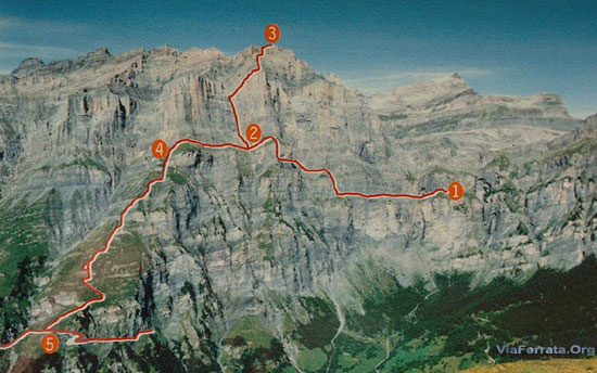
 

Length and Altitude

Start: 2'060 m
Summit of the Via Ferrata: 2'941 m 


Time of Year

July to end of September.


Timing

Mieläs-Loèche les Bains; about 5h
Daubenhorn; about 8h, 6 hours of via ferrata, 2h of downhill


By Car

From Geneva take the highway towards Lausanne-Sion. From Chamoix and Aosta go towards Martigny and then towards Sion.

After Sion, continue towards Sierre- La Souste and then zoom zoom towards Brig.

In Susten, go left towards Loèche les Bains, or Leukerbad (over there they speak German)

Drop your car off in front of the Gemmi lifts, it's cheapest and most practical solution. All the parking lots of the resort are paying and are watched with the eyes of a hawk. The debts accumulated by the old big shots of the region have not all been paid off yet!


By Train

Go to Sierre with the train and then take the bus from the train station. Contact the SBB schedules and fares.


Access

De la station du téléphérique (2'346 m) jusqu'à l'ancien chemin de la Gemmi et l'ancienne voie du col après quelques tournants (des rampes partiellement), puis en redescendant jusqu'à la Untere Schmitte où un panneau indique la via ferrata (env. 2060 m), 20 min.

From the lift station (2,346 m) to the old Gemmi trail and the old route for the pass, after a few turns (partially with handrails), and then going down to the Untere Schmitte where a sign points out the via ferrata (about 2060m), 20 min.

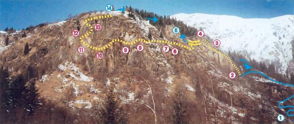
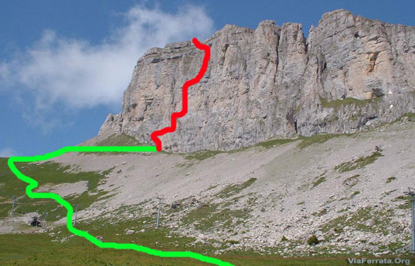
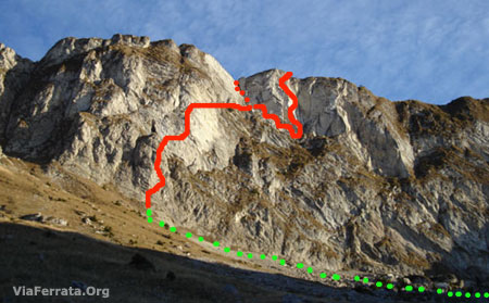
Little via ferrata : A well marked trail goes through a first incline, and then starting at a wild cirque flattens out until you reach the first cables of the via.


Via Ferrata Part 1: Mieläs:

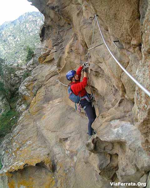
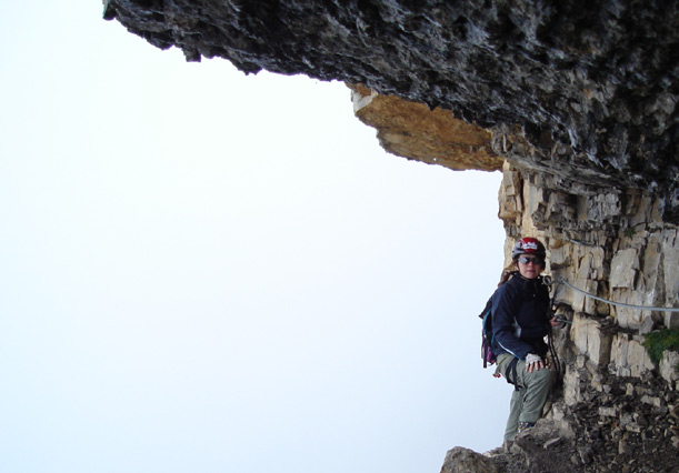
You start this jam-packed day with a long traverse between rock and trails. It looks a lot like climbing. You are constantly in contact with the rock. There are few stakes and no steps. You have the option of either clutching the cable or playing with the rock.

Here, a surprise, you will discover the first aldder. You won't need to take a picture, it's not the last one you'll see... this via is a series of ladders!!!

Before getting to the junction of the Daubenhorn via or the junction that allows you to go back down to the Gemmi, 76 m of ladders await you.


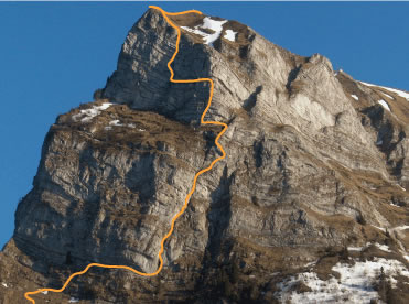
Beginning of the 2nd part - The Chimney

You have chosen, then, the most athletic option of the day. This part is fairly dangerous. The void is ever present. A very beautiful section in the cavern is the source of a rather refreshing and relaxing moment, which is much appreciated before attacking a section that is a bit more strenuous and slightly overhanging.

At the summit, take a little break to sign the golden book and then keep going on to the final part.

Be warned! If you eat your munchies here, make sure that you are on the true summit. Some are tricked and believe they are finished when actually...

The last ladder is fairly strenuous, especially because of the fatigue accumulated during the day.

The last part was made longer with the addition of an extra section through a sort of tunnel. This is, however, a physical variant, and you can avoid it.


Way Back

Account for 1h30 to 2h.
Go onto the snowfield and exit on the left at the bottom. The trail is marked with red and white markings.
 

Where to Spend the Night

Contact the Tourism Office. It's not easy to find a place to catch some zzzzs. There are plenty, but the resort is not very affordable.
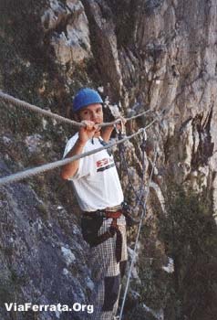
 

Photos


par gmillioud Youtube

par Celine Schlegel Youtube

Via Ferrata des Rochers de Naye, Montreux, Vaud


   Footbridge      Monkey Bridge       Ladder          Zipline    
0 0 1 0


Features

One of the most beautiful via ferratas in the world with a splendid view on Lake Geneva. Lots of contact with the rock for both hands and feet. A gem!

Not for everyone. Reserved for those with experience and strong arms.

The last part is opens only on the first of July (due to nesting birds)


ViaFerrata Tips and Tricks

Bring your MTB aboard the Golden Pass train and also a camera because the landscape is splendid. You can ride down all the way to Montreux. Nonetheless the Golden Pass train costs an arm and a leg.

You can choose to go down the caverns (on the way back). Bring a headlamp and try not to wear white pants!

Take some good hiking shoes (with vibram). You'll be in contact with the rock frequently and sometimes with muddy earthy grass sections. It is prohibited to wear tennis shoes (as it is, in fact, for all via ferratas).


Grade

 Strength    4
 Dizziness    4
 Type       High Mountain: 2
 Technics            1
 Evaluation   Extreme


Information

Tourism Office Tourisme Montreux


Length and Altitude

Elevation gain : 160 m
Start : 1'856 m
End: 1'993 m
Length: 600 m


GPS Coordinates

Parking: if you go by car
N 46,27 091
E 06,58 634

Start of the via ferrata:
N 46.436587848039
E 6.9806818993206


Time of Year

May to November (snow).


Timing

Approach from the the train stop: Jaman Station: 30 minutes
Approche from the parking lot: 50 minutes
Via Ferrata: 1h30 
Way Back Option A: 5  minutes to get on the train from l'Hôtel de Naye towards Montreux
Way Back Option B: if you go through the caverns (bring a headlamp) its really nice. Account for 1 hour to the Jaman train stop and twenty minutes to get to the parking lot.


By car

From Lausanne: Vevey highway, exit in Montreux.
Go towards Glion- Caux.
Continue to the Rochers de Naye and park your car at the Col de Jaman.


By train

Via the Golden Pass from Montreux to the Rochers de Naye. Get off at the Jaman stop.

36.-- Frs per person there and back (18.-- with the half-fare)


Access

From the Jaman station, the via ferrata is located straight ahead of you.

Go down the path to the ruins of an ancient mountain pasture chalet. Follow the markings to the via ferrata.

Via Ferrata

The via ferrata is located between the Tour de la Chaux de Naye and the Rochers de Naye of the north-west side.

The beginning of this via ferrata is a selective process: a vertical 50m rocky spur and you will reach a ladder.

You keep going on a narrow ramp that leads out onto a series of grassy ledges which bring you to the bottom of an escape route.

If you are in shape and feeling good, keep going on the trail that goes down. Otherwise, opt for the escape route that goes up.

If you keep going, you are going to have to face the void and especially the rock wall (sometimes overhanging) that really works your arms. It is demanding and takes a lot of energy (not for beginners).

Way Back

Two options:

Option A: 5  minutes to the train from l'Hôtel de Naye towards Montreux (18.-- Frs to get to Montreux or 9.-- Frs to Montreux with the half-fare)

Option B: through the caverns

If you go through the caverns, each person must have a headlamp. It is very beautiful, and you must not be too big as there is a pretty narrow section. It's vertiginous. Account for 1h45 to get back to the Jaman train stop.

Where to Sleep

Check with the Tourism Office.

Photos

List of the Via Ferrata in France

List of the Via Ferrata in France

The via indicated below are translated into English. Not all via are mentionned, but they are coming!

 No    Via Ferrata  Location  Level    Features 
   01 Ain      
78  Via Ferrata Fort de l'Ecluse  Làaz  Mid Difficult  
79  Via Ferrata Guinguette  Hostias - Tenay  Difficult  
   03 Allier      
81  Gorges du Haut Cher  Lignerolles  Mid-Difficult  
   04 Alpes Hautes Provences      
24  Via Ferrata Grande Fistoire  Le Caire  Very Difficult  zip line, footbridge, monkey
 bridge. All year long
         
   05 Hautes Alpes      
14  Via Ferrata Aiguillette
 du Lauzet
 Le Monêtier les Bains   Not Difficult  At 2'600m. Rando-Via
 June - October
15   Via Ferrata Croix
 de Toulouse
 Briancon  Initiation  For beginners
 April - November   
 16   Via Ferrata
  Mines du Grand Clos
 La Grave  Difficult  High Mountain. Long.
 April - November
18  Via FerrataFerrata
 La Balme et Colombier
 Argentière 
 Les Vigneaux
 Difficult
 Very Difficult
 2 via. not for beginner
 All year long
20  Via Ferrata de Tournoux  Puy St-Vincent  Mid Difficult  Beginner accompanied
 May - October
21  Via Ferrata
 de la Grande Falaise
 Freissinières  Difficult  You touch the rocks
 April - November
22  Via Ferrata Les Vires
 des Gorges Agnielles
 La Faurie  Beginner
 Very Difficult
 2 part. A) for kids/parents
 All year long. Short
29  Via Ferrata Le Rocher Blanc
 Serre Chevalier
 Saint Chaffrey
 mid-difficult
 Difficult
 2 via. Need Gondola
 July - August 
30  Via Ferrata Rocher du Bez  Serre Chevalier  Initiation  Steps for kids!
 April - November
   06 Alpes Maritimes      
25  Via Ferrata Baus de la Frema  Colmiane  Difficult
 Extreme
 Footbridge, monkey
 April - October
26  Via Ferrata Comtes Lascaris  Tende  Very Difficult   Zipline, bridges. Not for kids
 May - October
31  Via Ferrata de Peille  Peille  Extreme  Zipline, net. Must book in
 advance.  All year long.
   Via Ferrata La Ciappea  La Brigue  Very Diffiult  Zipline, Bridges
 Not always open. Check
   Via Ferrata
 Les Demoiselles du Castagnet
 Puget-Thenier  Extreme  Zipline, bridges
 Year long
   09 Ariège      
52  Via Ferrata du Vicdessos  Vicdessos  Initiation
 Difficult
 Call to reserve. Bridges
 April - October
   Via Ferrata des Estagnous  Castillon en
  Causeran
 Difficult  High-Mountain
   12 Aveyron
     
56  Via Ferrata
 Bois des Baltuergues
 St-Geneviève
 sur Argence
 Difficult  
71  Via Ferrata du Boffi  Millau  Mid-Difficult
 Difficult
 Zipline, bridge, fun
 Closed March 15-May 15
   14 Calvados      
 11   Via Ferrata des Rochers
 de la Cambronnerie
 Clécy  Easy  For beginners. Fees.
 All year long
         
   20 Corse      
   Via Ferrata La Manicella  Moltifao  Difficult  7 ziplines! Fees
 Year long
   Via Ferrata de Chisa  Chisa  Difficult  
   38 Isère      
17  Via Ferrata St-Christophe  St-Christophe en
 Oisans
 mid-Difficult  Above a river. For Beginners 
 April - November
19  Via Ferrata des Perrons  Venosc
 Les 2 Alpes
 Difficult  Like Rock climbing
 May - October
32  Via Ferrata Prise
 de la Bastille
 Grenoble  Difficult
 Extreme
 2 via. Footbridge. Tough
 Year long (if no snow)
   Via Ferrata Pierre Ronde
 Gorges de Sarenne
 Alpe d'Huez  Mid-Difficult
 Difficult
 2 via near the resort.
 June - October
55  Via Ferrata Croix des
 Trois Fontaines
 Chamrousse  Mid Difficult  Access via Gondola. Watch time
 and day. June - October
   42 Loire      
36  Via Ferrata Planfoy  Planfoy  Initiation
 Mid-Difficult
 2 via: 1 for kids. Zipline
 footbridge. Year long
   65 Hautes Pyrénées      
   Via Ferrata Chaos de Coumély  Gedre,
 Gavarnie
 Difficult  Moving footbridge
 April - November
   Via Ferrata Pont de Napoléon  Luz Saint Sauveur    
   66 Pyrénées Orientales      
33  Via Ferrata Les Escaldilles  Llo  Initiation
 Very Difficult
 3 via. Footbridge
 Expensive.  July - August
116  Via Ferrata Panoramique
 and Pichona de Fenouillèdes
 Saint-Paul de
 Fenouillet
 Difficult  2 via. For beginners & confirmed
 3 bridges. Year long
   73 Savoie      
04  Via Ferrata Pas de l'Ours   Ugine 74 Haute S  Difficult  Rando-Via-Ferrata
 June - October
 05  Via Ferrata de la Grotte
 à Carret
 St-Jean d'Arvey  Extrem
 Very Difficult
 2 via. Very solid
 May - October
 06  Via Ferrata les Bettières  Peisey Nancroix  Initiation
 Very Difficult
 3 via
 May - October
07  Via Ferrata Croix des Verdons  Courchevel  Very Difficult  High Mountain
 Mid-June - Mid-October 
 08   Via Ferrata des Plates de
 la Daille
 Val d'Isère  Very Difficult  Really works your arms
 June - October
 09  Via Ferrata La Chal  St-Colomban  Difficult  Funky. Bridges, fun
 All year long
 10  Via Ferrata de la Cascade
 et le Bastion
 Pontamafrey  Difficult
 Very Difficult
 2 Via
 Currently closed 
12  Via Ferrata Poingt-Ravier  Valloire  Initiation
 Easy
 For Beginners
 May - October
 35  Via Ferrata Nant de Rossane  Les Aillons  Initiation
 Difficult
 3 via. Zipline, Ladder, bridges
 April - November
46  Via Ferrata Lac de la Rosière  Courchevel  Initiation  Moving Monkey bridge, long
 footbridge. June - October
47  Via Ferrata Cascade de la Fraîche  Pralognan
 La Vanoise
 Very Difficult  Impressive monkey bridge
 above cascade. May - October
48  Via Ferrata Plan du Bouc  Champagny en
 Vanoise
 Initiation  Possible for kids. Forbidden
 between November and May
   Via Ferrata du Rocher St Pierre  Valloire  Extreme  Footbridges, ladders, monkey
 bridge. June - October
   74 Haute Savoie        
 02  Via Ferrata Yves
 Pollet Villard
  La Clusaz    Very Difficult   Long footbridge
 May - Mid-November  
 03  Via Ferrata
 Tour de Jalouvre
 Grand Bornand  Very Difficult  Very long footbridge
 June - November


Warning

Via Ferrata (read before you select a via ferrata)

The information provided in this website may be not accurate. It is up to you to select a via you would like to climb. More information can be collected to the Tourism Office or the Mountain Guide Office.

ViaFerrata.com and ViaFerrata Sarl is not responsible in case of wrong information or comments. They are only provided as indication.


List of the Via Ferrata in Switzerland

List of the Via Ferrata in Switzerland

- Look at the Swiss Via Ferrata Map
 

   Via Ferrata Name
 Location   Grade  Features
  Valais      
 501  Via Ferrata
 Moiry Dam
 Grimentz  Difficult
 Extreme
 Zip line, nice view.
 April to November
 527  Via Ferrata Farinetta  Saillon  Very difficult
 to Extreme
 Start with a challenging bridge.
 March-Nov.
 503  Via Ferrata de Tière  Champéry  In 2 parts: Beginner
 Difficult
 Follow the river. Bridges
 March-November

 513  Via Ferrata Evolène  Evolène  Extreme  Last part is very solid
 Not for beginners. April-Nov
 511  Via Ferrata
 Jägihorn Weissmies
 Saas Fee
 Very difficult
 Very long with a beautiful view.
 Abore 3'000m. June-Sept
 510  Via Ferrata
 Baltschiedertaler
 Baltschieder  Very difficult
 High Mountain. Few gear
 June-October
 517  Via Ferrata
 in Loèche
 Loèche  Very difficult
 Lot of rock falls. Hazardous
 Nombreuses chutes de pierres
 516  Via Ferrata
 du Belvédère
 Nax  Easy  For beginners
 March-November
 521  Via Ferata Schweifine  Zermatt   Difficult  3 via.
 Near the center of Zermatt
 
 528  Via Ferrata Gabi  Simplon
 Gondo
 Difficult  Near the Simplon pass
 April-October
  Vaud      
 504  Via Ferrata Cascade  Les Diablerets  Extreme  Need strength
 May - November
 502  Via Ferrata
 Rocher Jaune
 Tête de Chamois
 Les Diablerets  Difficult  High Mountain.
 Near the telecabine
 June-October
 530  Via Ferrata 
 Dames Anglaises
 Les Diablerets  Difficult  High Mountain
 June-October
 505  Via Ferrata
 La Tour d'Ai
 Leysin  Difficult  Suitable for solid beginners.
 May - october
 518  Via Ferrata Plan Praz  Leysin  Extreme  In the village. Need strength
 April - November
 506  Via FerrataFerrata
 Videmanette 1-2
 Rougemont  Initiation / Beginner  Short, easy
 June - September
 507  Via Ferrata Sportive
 Videmanette 3
 Rougemont  Very difficult  Strong! Dizziness
 June - September
 522  Via Ferrata
 la Splendide
 Rocher
 de Naye
 Extreme  Wonderful! Great view
 May - November
 529  Via Ferrata du
 Lavanchy
 Pont de Nant
 Plan sur Bex
 Difficult  Short but tough
 April - November
  Bern      
 508

 Via Ferrata Tälli

 Meiringen  Initiation
 Very difficult
 2 via: Kids or Pros
 July - October
 519  Via Ferrata
 Allmenalp
 Kandersteg  Extreme  Ziplines, bridges. Technics
 June - October
 524   Klettersteig Ferrata
 Gantrisch
 
 Gantrisch  Difficult  Very long: 5h. Ladders
 June - October
  Fribourg
     
 514  Via Ferrata
 Voie Hohl La Face
 Moléson
 Gruyère
 Very Difficult  Not for beginner. Fees
 April - October
 515  Via Ferrata
 Le Pilier
 Moléson
 Gruyère
 Difficult  Dizziness. Watch opening time
 April - October
  Neuchâtel      
 512  Via Ferrata
 du Tichodrome
 Noiraigue  Easy  For beginners and kids
 Closed January 1 until July 1
  Glaris      
 526  ViaFerrata 
 Eggstock
 Braunwald  Extrem  In 3 parts. Long 5h30
 June - October
  Uri      
 509  Via Ferrata
 Diavolo
 Andermatt  Initiation  For beginners
 June-October
  Tessin      
 520  Via Ferrata
 Salvatore
 Lugano  Very Difficult  At the top of the Funiculaire
 June to October
   Grison      
 527  Via Ferrata Piz Mitgel   Savognin   Difficile  Longue journée, 5h montée, 3h descente
 Aérienne en haute montagne 
 525  Via Ferrata Pinut  Flims   Facile  La plus vieille via ferrata en Suisse (1900) 
 Passages suspendus
 523  Via Ferrata
 Sulzlfluh
 Sankt Antonien  Very Difficult  Long and strong. Ladders and bridge
 June - October
         

Warning

Via Ferrata (read before you select a via ferrata)

The information provided in this website may be not accurate. It is up to you to select a via you would like to climb. More information can be collected to the Tourism Office or the Mountain Guide Office.

ViaFerrata.com and ViaFerrata Sarl is not responsible in case of wrong information or comments. They are only provided as indication.