12 Via Ferrata Poingt-Ravier, Valloire, Savoie, France

Via Ferrata Poingt-Ravier, Valloire, Savoie


Topo: ski-valloire.net

   Passerelle      Pont de singe        Echelle         Tyrolienne   
0 0 0 0
 

Caractéristiques

Historiquement la première ferrata équipée en Savoie! Une belle invitation pour une initiation et pour débuter en douceur. Tu ne trouves pas de réelles difficultés et tu profites d'un beau point de vue.


Conseils ViaFerrata

Plein Sud! A parcourir le matin de préférence.

A recommander aux personnes qui ont une apprénhension du vide.


Cotation

 Physique 1
 Gaz 2
 Type      Montagne: 1
 Technique            1
 Evaluation Initiation / Peu Difficile


Information

Office du Tourisme de Valloire

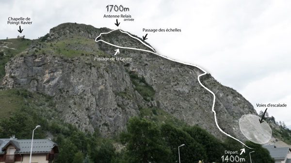
Longueur & Altitudes

Départ viaferrata :  1’450 mètres     
Arrivée viaferrata :  1’650 mètres     
Longueur :  500 mètres
Dénivelée :  200 mètres


Période

Mai à octobre, selon la neige


Horaire

Accès Via Ferrata : 1 minute
Poingt-Ravier: 2 heures
Retour : 30 minutes


Par la route

Autoroute A43 jusqu'à St Michel de Maurienne, à 17 km de Valloire + CD 902. Col du Galibier ouvert de début juin à fin octobre selon les conditions météo.


Par le Train

Voir avec la SNCF pour les bus et train.


Accès

Parking de la Borgée et suivre le torrent la Valloirette en rive gauche sur 150m, et un sentier à gauche te conduit au départ.

Le départ est également celui de la via ferrata du Rocher Saint Pierre.


Via Ferrata 

Recommandée pour les débutants. C’est une jolie promenade.

La via ferrata débute par un petit mur puis t’emmène au dessus de Valloire avec un très beau panorama avec un équipement nombreux qui rend la montée aisée. Tu continues sur plusieurs dalles pour arriver sur une vire aérienne sur ta gauche.

A nouveau des dalles et des traversées courtes pour joindre une plate-forme herbeuse. Ici, tu as deux options
A) tu prends la Grotte à gauche, parcours très simple
B) à droite et tu rejoins le sommet par une suite de dalles et de passages dans l'herbe.   


Retour

La descente se fait par un chemin en terre battue pour rejoindre le le hameau de Poingt Ravier et tu y trouveras le chemin éco-sylve ou le sentier de la Borgée.


Ou dormir

Gîte d'étape les Réaux près de Bonne nuit, 19 places,


12e Via Ferrata Poingt-Ravier, Valloire, Savoie, France

Via Ferrata Poingt-Ravier, Valloire, Savoie

 
Topo: ski-valloire.net


     Footbridge     Monkey Bridge    Ladder      Zipline   
0 0 0 0


Features

Historically the first equipped via ferrata in Savoie! An open invitation for beginners to start off smoothly and gently. You won't come across any real difficulties and you can make the most of a beautiful viewpoint.


ViaFerrata Tips and Tricks

Fully south facing! It's better to go up it in the morning.

Recommended for those who have a fear of heights.


Grade

 Strength 1
 Dizziness 2
 Type      Mountain: 1
 Technics         1
 Evaluation Initiation / Easy


Information

Valloire Tourism Office


Length & Altitudes

Start of the viaferrata :  1,450 meters   
End of the viaferrata :  1,650 meters    
Length :  500 meters
Elevation gain :  200 meters


Time of Year

May to October depending on the snow


Timing

Via Ferrata access : 1 minute
Poingt-Ravier: 2 hours
Way back : 30 minutes


By Car

Highway A43 to St Michel de Maurienne, 17km from Valloire, then CD 902. The Galibier pass is open from the beginning of June to the end of October depending on the weather conditions.


By Train

Check with the SNCF for buses and trains.


Access

Borgée parking lot. Then follow the Valloirette stream on the left bank for 150m and a path on the left will lead you to the start.

This is also the start for the Rocher Saint Pierre via ferrata.


Via Ferrata 

Recommended for beginners. It's a very nice route.

The via ferrata start off with a small wall and brings you above Valloire where you have a magnificent panorama. There is plenty of equipment which makes the climb easy. You keep going over several slabs to get to an aerial ledge on your left.

Once again you'll have some slabs and short traverses to get to a grassy platform. Here you have two options


A) go into the "Grotte" (cave) on the left, a very easy route
B) go right and you'll get to the summit via a series of slabs and some grassy sections.


Way Back

The way down is on a dirt trail that leads you to the hamlet of Poingt Ravier. From here you will find the "éco-sylve" trail or the Borgée trail.


Where to Spend the Night

Stopover lodge "les Réaux près de Bonne nuit", 19 spots available