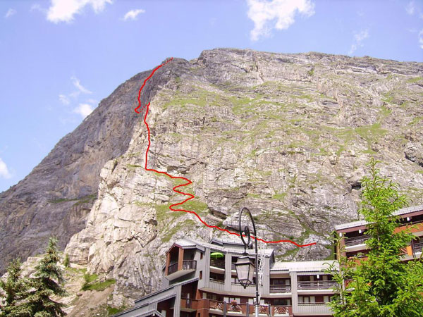
Via Ferrata des Plates de la Daille, Val d'Isère
Topo par AltitudeRando.com
| Passerelle | Pont de singe | Echelle | Tyrolienne |
| 0 | 0 | 0 | 0 |
Caractéristiques
Une via ferrata à bras le long d'une dalle. Située en face de la via ferrata de Roc de la Tovière.
 Conseils ViaFerrata
Partir tôt le matin car le soleil est très fort quand il y a du soleil!
Cotation
| Physique | 4 |
| Gaz | 4 |
| Type | Haute-Montagne: 2 |
| Technique | 1 |
| Evaluation | Très difficile |
Information
Office du Tourisme de Val d'Isères
 Longueur & Altitudes
Départ Via-Ferrata:1'800 m.
Sommet Via-Ferrata : 2’216
Dénivelé : 416 mètres
Longueur : 650 m
Coordonnée GPS du départ
Période
Juin à Octobre (haute-montagne)
Horaire
Accès Via-Ferrata: 5 min
Via-ferrata : 2h à 3h
Retour : 45 min
 Par la route
N53 Grenoble, Albertville, Chambéry. A43 Alberville.
RN90 Bourg Saint Maurice D902 Val d'Isère env 28 km de Boug St-Maurice
 Par le Train
Voir avec la S.N.C.F .


 Accès
Accès
Tout à l'entrée de Val d'Isère, à gauche en montant à Val d'Isère en face du premier grand immeuble.
Via Ferrata
Cette via ferrata est très physique avec un gros surplomb dans la première partie de la montée avec un mur de 20m. Il aura besoin de tes bras et de self control pour maîtriser le vertige.
Tu vas découvrir deux piliers assez raide et gazeux pour arriver sur une descente en dévers, toujours dans une ambiance de gaz. Tu as à nouveau une partie à bras avec un surplomb et tu continues le long de la dalle jusqu’à son sommet dans un cadre très gaz avec une très belle vue Val d’Isère.
Retour
Compte 45 minutes par le sentier
 Ou dormir
Voir avec l'Office du Tourisme
Photos


par Mark Hayes, Youtube
Si tu as une autre vidéo à nous proposer, contacte-nous