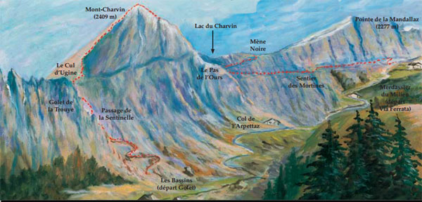
Via Ferrata Pas de l'Ours et Golet de la Trouye, Ugine
| Passerelle | Pont de singe | Echelle | Tyrolienne |
| 0 | 0 | 1 | 0 |
Caractéristiques
Il s’agit plus d’une course d’escalade, une randonnée sécurisée par une ligne de vie qu'une via ferrata classique selon le standard français. La via est intégrée à une randonnée menant au sommet du Mont Charvin. Les tronçons de câble sont parfois assez long: 10 m.
Les deux via ferrata ne sont pas connectées l’une à l’autre: La Via Ferrata du Pas de l’Ours et la Via Ferrata du Golet de la Trouye
 Conseils ViaFerrata
Il te faut impérativement un casque, d'excellentes chaussures de marche et une corde dans ton sac si tes collègues de randonnées sont sensibles au vide. C'est une randonnée équipée, mais pas toujours. Parfois glissant et dangereux.
Sens du circuit recommandé: Montée du Golet de la Trouye, Arrête Sud, Arrête Est, Via Ferrata du pas de l'Ours, Merdassier du Milieu
Cotation
| Physique | 1 |
| Gaz | 4 |
| Type | Haute-Montagne: 1 |
| Technique | 1 |
| Evaluation | Difficile |
Information
Office du Tourisme de Ugine
 Longueur & Altitudes
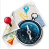
Départ Via Ferrata: 1'585 m
Sommet Via Ferrata Pas de l'Ours: 2'130 m
Dénivelé: 545 m
Longueur totale 250 m.
Sommet Via Ferrata Golet de la Trouye: 2'410 m.
Coordonnée GPS du départ
Période
Du 15 juin au 15 octobre
Horaire
Via ferrata allez-retour: 5h00.
Approche: 1h00
Total de la journée: 5h-6h
Par la route
Ugine se trouve à un jet de pierre d'Albertville
 Par le Train
Voir avec la S.N.C.F .


 Accès
Accès
D'Ugine, prends la route qui mène au Col de l'Arpettaz, puis suivre la route carrossable des Montagnes
d’Ugine jusqu’au chalet de Merdassier du Milieu à 1585 m.
Parking.
Du chalet de Merdassier du Milieu, on atteint le départ par un sentier longeant la crête qui relie la Tête de l’Aulp au Mont-Charvin en 1h30 environ.
Via Ferrata
Passage naturel, la Mène Noire est une vire étroite entre une bande de schiste et de calcaire. La suivre sur 250 m grâce au parcours équipé de câbles qui débouche sur l’arête faîtière du Mont-Charvin où la vue se dégage sur les Alpes et où on domine la vallée de Manigod et tout près le lac du Charvin.
En remontant l’arête assez aérienne, tu parviens au sommet 2409 m, bordé au Sud par des parois rocheuses. Du sommet on jouit d’un magnifique
panorama sur l’ensemble des Alpes du Nord, ainsi que sur les Massifs du Mont-Blanc et du Beaufortain.
Descendre par le même itinéraire.
Retour
Compte 1h.
 Ou dormir
Voir avec l'Office du Tourisme. Il y a un camping à proximité.
Photos


par Chaîne de zebrprod, Youtube