Via Ferrata Barrage de Moiry, Grimentz


  Foot Bridge   Monkey Bridge    Ladder     Zip line        Net    
 1  0        0       85 m 1
  

Features

This Via Ferrata is very well equiped and it has many points of contact with the rock. With a little bit of luck, you might even catch a sight of some alpine ibex nearby. But, to see them… shhhhh!

You can enjoy a zip line and a overhanging net!

A third part was opened with the famous net and a table for you to eat a fondue or a picnic!


Via Ferrata Tips and Tricks

Due to its ideal location, it is possible to follow the climbers’ progression from the top of the dam. A rappel station was installed, length 48m. You must have the necessary equipment and skills to do it.


Grade

 Strength  partie 1: 2
 partie 2: 4
 partie 3: 2
 partie 6: 4
 partie 7: 2
 Dizziness  partie 1: 3
 partie 2: 3
 partie 3: 3
 partie 6: 4
 partie 7: 3
 Type      Mountain: 1
 Technics           3
 Evaluation  Partie 1: Difficult
 Partie 2: Extrem (with a way out)
 partie 3: Difficult
 partie 6: Extreme (but you can avoid it)
 partie 7: Very Difficult


Information

Tourism Office Grimentz St-Jean
Phone 027 476 1700 Outside of Switzerland: ++41 27 476 1700


Length

410 m. (sans échapatoire)
Climb : 230 m
Start : 2'120 m
Finish : 2'350 m


GPS start

N 46'08'371
E 007'34'391
Alt. 2'164 m.


Time of Year

The Via Ferrata is open from mid-June to the end of October depending on weather conditions.

Access by private car depends on the closure of the Moiry dam road. Outside of this period, it is possible to access the Via Ferrata by foot. Account for 1h30 of walking from the village of Grimentz.


Timing

Approach from the parking at the bottom of the dam: 10 minutes,
Via Ferrata: 1h30 - 2h
Back to your car : 10 min following the road inside the tunnel


By Car

Take the A9 Martigny-Sion-Sierre highway. Get off at the second exit in Sierre and follow “Val d’Anniviers” (right at the roundabout and then right again) towards Grimentz. 25km further you will arrive in Grimentz.

Then head towards the Moiry dam (8km) either by car or with the postal bus (during the high season).

By Train

Contact the CFF . You can go by train to Sion. Then the Bus to Grimentz and the dam.  The Bus is not working in winter.


Access

25km from Sierre, you will find the picturesque village of Grimentz. From the village, you simply need to follow the road that goes up towards the Moiry dam (8km) by car or with the postal bus.

Once you have reached the base of the dam wall, you will find a parking lot at your disposal. To reach the starting point, you simply need to follow the road for 150m and then climb to your right to access the beginning of the Via Ferrata. Signs should be there to show you the way.
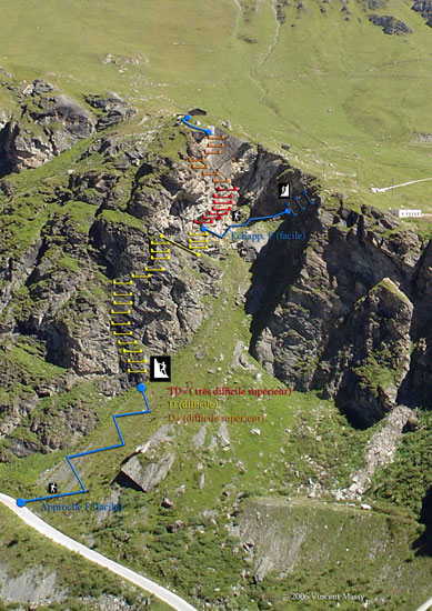
 

Via Ferrata 

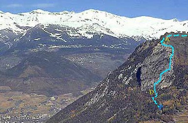
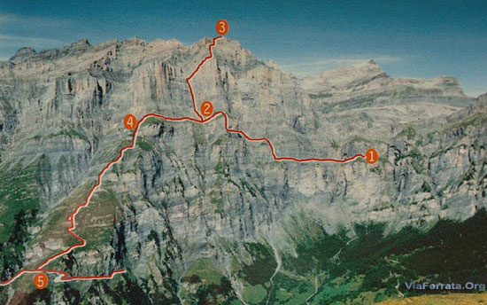
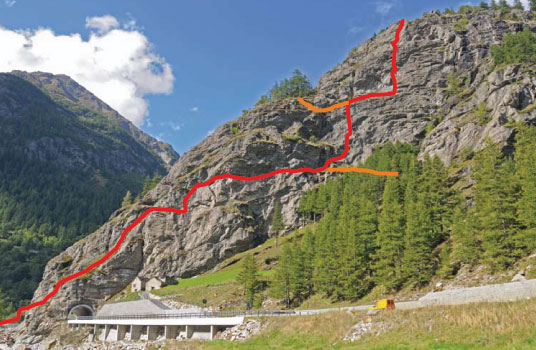
The first part of the Via Ferrata is located on a vertical wall. You will already feel a lot of tension in your arms and the route climbs quickly. This part really works the arms and certain sections are very demanding.  The first part ends on a precipitous rocky spur with an enchanting view on the Val d’Anniviers.

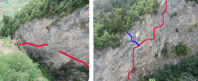
Afterwards, you cross an easy ledge with a small vertical projection to get to the second part as well as the way out.

At the top of the first part you have a choice, either you can go to the left to climb the second part,very enjoyable with a breathtaking and turquoise view of the Moiry Lake; or you can continue, cross an easy ledge with a small vertical projection to get to the sixth part, Very Difficult, or take the way out, or go to the foot bridge (it moves and the wood plates are small).

The sixths part is frankly very difficult. You must be in excellent physical condition and your arms need to be strong! This part begins with a 20m overhanging traverse!!! It is extremely tough and not meant for all hands. Once you have passed the overhang, the route continues more calmly for your tired arms, but it is very precipitous and still quite demanding.

You will arrive at the junction between the third and sixth parts. You can either continue on to the third part or head towards the seventh part (picnic table and netting)


Zipline
For security reasons: only with a guide (the key can be found at the “Restaurant du Barrage de Moiry”)
The zip-line is 85m long, 60m high and has a 20m vertical drop.


Return to Home

From the final exit point follow the marked path down to the Moiry dam. There, you have two possibilities:
-follow the road down, faster, but not very interesting: 10 min (by going through the tunnel)
-cross the dam wall and follow the pedestrian path down: 40 min

For those who are more tired, take the postal buses that run during this time period
(The official bus stop is located in the Via Ferrata parking lot).


Where to sleep

There is a camping in Grimentz and plenty of places to spend the night. It’s a lovely village!


by ViaFerrata.org Youtube


Gallery


Via Ferrata de Tière, Champéry, Valais


Passerelle  Pont de singe    Echelle    Tyrolienne 
     2              0        0       0
   

Caractéristiques

Débute par de très belles passerelles qui par la proximité de la cascade donnent un bon frisson.
En grande partie en traversée. Un passage un peu sport et à bras sur 3-4 mètres peut freiner les débutants.


Astuce ViaFerrata

Laisse une voiture navette à l'arrivée de la ferrata. Le chemin du retour au village est un peu long… Si tu as un mountain bike, il fera l'affaire, d'autant que la région se prête à merveille.

Si tu décides de faire le tout à pieds, passe par les Galeries Défago (un chemin taillé dans une parois). A côté de la via et c'est une belle ballade dans une parois vertigineuse mais accessible à tous.

Un peu chaud en été durant l'après-midi. La faire le matin quand elle est encore à l'ombre.


Cotation

 Physique  Partie 1:  1
 Partie 2:  2
 Gaz  Partie 1:  1
 Partie 2:  2
 Type   Montagne
 Partie 1:  2
 Partie 2:  1                     
 Technique                2
 Evaluation  Partie 1:  Initiation
 Partie 2:  Difficile (passage difficile sur 3-4 m)


Information

Office du Tourisme de Champéry


Longueur

Longueur 460 m.
Dénivelé 125 m.
Altitude de départ de la via Ferrata 1'126 m.


Coordonnée GPS

N 46'10.630
E 006'53.013


Période

Mai - Octobre


Horaire

Marche d'approche: env 30 minutes depuis le Centre Sportif (au village). 10 minutes depuis l'arrivée
Via Ferrata 30-45 minutes
Retour: 45-60 minutes pour revenir au Centre Sportif


Par la route

Genève-Lausanne, prendre direction Martigny-Sion-St-Bernard. Sortir à St-Triphon/Monthey.
Prendre le tunel qui monte dans la Vallée direction Champéry-Morgins.
A Troistorrents prendre la route direction Champéry.


Par le Train

Prends le train jusqu'à Aigle. Ensuite l'AOMC direction Champéry. Le terminus du train se trouve à un jet de pierre du chemin qui mène à la via ferrata.
Contacte les CFF , pour les horaires et le tarif des trains et bus.


Accès

Option 1
Vas vers les tennis qui se trouvent à côté de la gare du téléphérique et du train. Au tennis et devant le Paladium (méga centre sportif), descends le Chemin duTavis et pont du Sous-Sex qui va en direction de la rivière. Laisse ta voiture vers le petit pont de bois. Traverse le pont à pied et tu verras un panneau sur la gauche qui débute le chemin qui monte à travers les bois et qui mène à la ferrata.

Option 2
En voiture, vas en direction du Grand-Paradis. Juste avant d'arriver au Grand Paradis 200 m après le pont de pierre que tu passes en voiture, prends à gauche juste avant le petit pont qui enjambe la rivière.

Ne traverse pas la rivière mais longe-là. Prends la route qui part à gauche et suis-là. Dès que tu arrives à une jonction qui se trouve vers un tout petit pont qui enjambe une petite rivière, tu y es. Le chemin qui mène au départ de la via se trouve 8 mètres après le pont direction le Grand Paradis. Il descend sur la droite de manière assez raide.


Via Ferrata

Elle débute par une passerelle et une sorte de petite ballade pour te mettre en appétit. Une deuxième passerelle style via ferrata...et une petite montée qui met l'eau à la bouche pour arriver à la très belle et grande passerelle d'une dizaine de mètres au dessus de la cascade.

Tu auras un peu de repos le long d'une vire avant de voir l'Ours... si tu fais attention... il est caché dans une petite grotte! Celui qui ne le voit pas paie la tournée!

Ensuite, les choses sérieuses commencent. Un passage très physique sur 4 m, peu représenter un obstacle infranchissable pour les débutants, mais une fois passé, c'est un merveille. On regrette même que la ferrata se termine si vite tellement elle est agréable.


Retour

Voir plus-haut.
 

Où dormir

Camping à Champéry, au lieu dit le Grand Paradis.


{youtube}ri9valGZ5Ag|500|330|0{/youtube}
par ViaFerrata.com   Youtube


Photos

Via Ferrata de Baltschiedertaler, Baltschieder, Valais


 Passerelle  Pont de singe    Echelle     Tyrolienne 
1 0 0 0
  

Caractéristiques

Située dans un lieu magnifique. La vue et le cadre sont très beaux. Mais il te faudra une bonne journée pour la parcourir.
C'est long, style via ferrata dans les Dolomites.


Astuces ViaFerrata

Tu es en haute montagne, attention aux changements de temps.

Prends des habits chauds et assez de chocolat pour les forces. Evite d’y aller s’il a plu ou si c’est humide. Il y a beaucoup de passages glissants et pas toujours sécurisés.


Cotation

 Physique  4
 Gaz  3
 Type  Haute montagne: 3 
 Technique  3 
 Evaluation  Très Difficile 


Information

Wiwannihütte qui est la cabane qui s'occupe de la ferrata.


Longueur et Altitude

Altitude départ : 2'027 m
Altitude d’arrivée : 2'444 m
Denivellé:  910 m
Longueur Via Ferrata: 2'100 m


Coordonnée GPS


Période

Juin -  Octobre


Horaire

Approche Via Ferrata: 2h30 – 3h
Via Ferrata: 3-4 heures
Descente: 2h30


Par la route

Traverse tout le Valais en direction de Brigue.

Après la ville de Rarogne (Raron en allemand) et à proximité de Viège ou Visp, prends la direction de Baltschieder (Baltschiedertal).


Par le Train

Accès possible depuis Sion ou depuis le canton de Berne par le Lotschberg. Contacte les CFF, pour les horaires et le tarif.

Le point sur la carte indique la cabane Wiwanni.


Accès

Bon, je débute par un coup de gueule : le parking est payant !!! et c’est très cher. Compte un minimum de Frs 6 à 7.— pour ton arrêt dans la via. Bien plus, si tu dors à la cabane !

Revenons à nos moutons. Le dit parking se trouve en face du Restaurant le Sonnehalde.

Mais si tu n’aimes pas marcher, continue par la route payante en direction de Nirwarch (compte Frs. 10.--) et roule jusqu’à la première épingle à cheveux. Il y a un parking à proximité.

Sinon, tu peux laisser ta voiture en bas et faire ce bout à pied. Compte 30 minutes. 

De là, suis le sentier de la Cabane Baltschieder (suivre les marques rouge et blanche). Il y a un bisse sympa qui va t'accompagner jusqu’à ce que le chemin monte de manière plus pentue. Attention, ce chemin est vertigineux par endroit étroit.

Après une bonne grimpée, tu trouves sur ta gauche un chemin Blanc/Bleu. C’est le chemin de la via ferrata.


Via Ferrata

La Via Ferrata débute par un passage escarpé et ensuite dans une faille. La pente n’est pas très raide et tu es en contact avec le rocher. C’est sympa.

Ensuite tu arrives à un petit calvaire. Un chemin interminable dans l’herbe, la boue et les rochers. Un homme averti en vaut deux, donc pas de crise de nerfs !

Le câble s’interrompt pour un passage un peu scabreux et tu rejoins la deuxième partie de la via ferrata. Là, tu passes le long d’un grand rocher qui domine les gorges. Le paysage est splendide!

La fin de la via ferrata se termine le long d’une arrête rocheuse.


Retour

Compte 30 minutes pour arriver à la cabane en suivant le sentier Bleu/Blanc.


Où dormir

La cabane de Wiwannihütte  027 923 09 03  à côté du Wiwannihorn 3001 m.

Deux hôtels dans la région:

Hotel Bahnhof  027 946 22 59

Hotel Sonnenhalde  027 946 25 83.


Photos

Via Ferrata de Baltschiedertaler, Baltschieder, Valais


 Passerelle  Pont de singe    Echelle    Tyrolienne 
1 0 0 0
  

Features

Located in a magnificent area. The view and the setting are very beautiful. But you will need the better part of a day to complete it.
It's long, in the style of Dolomite via ferratas.


ViaFerrata Tips and Tricks

You are in a high mountain setting, be wary of changes in the weather.

Take warm clothes and enough chocolate to keep you going. Avoid going if it just rained or if the conditions are wet. There are a lot of slippery parts and they are not always secured.


Grade

 Physique  4
 Gaz  3
 Type  Haute montagne: 3 
 Technique  3 
 Evaluation  Très Difficile 


Information

Wiwannihütte, the hut that maintains the via ferrata.


Length and Altitude

Start: 2'027 m
Finish: 2'444 m
Elevation Gain:  910 m
Via Ferrata Length: 2'100 m


GPS Coordinates


Time of Year

June-October


Timing

Via Ferrata approach: 2h30 – 3h
Via Ferrata: 3-4 heures
Way back: 2h30


By Car

Cross the entire Valais towards Brig.

After the town of Rarogne (Raron in German) and near Viège/Visp, follow directions for Baltschieder (Baltschiedertal).


By Train

You can get there from Sion or from the canton of Bern via the Lotschberg. Contact the SBB, for schedules and fares. The cursor indicates the Wiwanni Hut.


Access

Well, I'm going to start with a rant: you have to pay for parking!!! and it's really expensive. Have a minimum of 6 to 7.— Frs. for your place at the via. And a lot more if you're planning on sleeping at the hut!

Back to the subject. The said parking is found across from to the Sonnehalde Restaurant.

But if you don't like to walk, continue on the toll road towards Nirwarch (account for 10.-- Frs.) and drive until you get to the first hairpin. There is a parking nearby.

Otherwise you can leave your car at the bottom and walk this section. This takes about 30 minutes.

From there, follow the path towards the Baltschieder Hut (follow the red and white markings). A nice stream accompanies you until the path gets steeper. Be careful this trail is vertiginous when it is narrow.

After a good climb, you will find a white/blue marked trail on the left. This is the trail for the via ferrata.


Via Ferrata

The Via Ferrata starts with a steep section and then goes into a crack. The slope is not very steep and you are in contact with the rock. It's nice.

Next comes a little ordeal. An interminable path in the grass, mud, and rocks. He who is forewarned is forearmed, so don't have a panic attack!

The cable is interrupted by a section that is a bit risky and then you get to the second part of the via ferrata. There, you will go along a big boulder that overlooks the gorges. The landscape is incredible!

The via ferrata ends along a rocky ridge.


Way Back

It takes about 30 minutes to get to the hut when following the blue/white trail.


Where to Spend the Night

Wiwannihütte  027 923 09 03  next to the 3001m Wiwannihorn.

Two hotels in the area:

Hotel Bahnhof  027 946 22 59

Hotel Sonnenhalde  027 946 25 83.


Media

Via Ferrata de Jägihorn, Saas Fee, Valais


   Footbridges    Monkey Bridge    Ladders     Zipline  
0 0 5 0
 

Features

Starts from a hut at 2,726m... 5 ladders with 400 rungs...


ViaFerrata Tips and Tricks

This is a veritable alpine route where you will climb all the way to 3,206m. Take the necessary clothes and equipment.
This ferrata is very long. You had better be feeling your best and in excellent shape to complete it.


Grade

 Strength  4
 Dizziness  3
  Type      High Mountain: 2
  Technics   2
  Evaluation Very Difficult
 

Information

Saas Fee Tourism Office

Guides de Saas Office


Length and Altitude

More than 1'000 m. of cable.
Start of the Via Ferrata: 2'820 m.
End of the ViaFerrata: 3'206 m.

GPS Coordinates


Time of Year

End of June to September.


Timing

Approach: 1h15
ViaFerrata: 3h00
Way back: 1h30
It takes 5-7 hours to complete the whole thing!!!

By Car

Valais highway towards Brig. From Brig go towards Saas Fee- Zermatt. It takes about an hour from Sion.


By Train

There is a train to this destination. Contact the SBB, for train schedules and fares.


Access

Take the Saas-Grund-Kreuzboden 2400 lift. Then for the approach you'll walk a good hour and 15 minutes.

From the Kreuzboden station (2,397m)  towards the Weissmies huts. A sign points to the via ferrata. Take the marked trail passing on the Triftbach, then climb the steep crest of the moraine until you get to the long flat traverse to the start of the via ferrata (about 2820m).


Via Ferrata

You go around a rocky projection on the left thanks to a life-line, then you climb on some steps in a characteristic couloir.

From there, it gets steeper and steeper. There are some hooks where holds are lacking. Be careful not to provoke any rock falls!

The rough and abrupt climb of the rock is stimulating, it is a bit vertiginous to the first ladder.

A series of ladders higher up the wall. It's fairly strenuous. You get to the final rungs via a steep slope, juste below the secondary summit (3150m).

To the left after a ledge is a secured almost continuous downclimb (a ladder) and it is partially vertiginous along the west ridge until the gap (3096 m) in front of the Jägihorn.

Go to the left of the sharp ridge (very original) to the starting point of the ascent towards the proper summit. At the rocky block, the climb is at first easy and then gets more and more steep and vertiginous. Now comes a particularly original abrupt section where the crampons are placed directly over the ridge.

To finish a flatter part leads to the wide summit.


Way Back

It takes about 30 minutes to get to the Weissmies Refuge by following the blue/white trail in the west face of the mountain that descends to a steep rocky couloir.

Be careful, it's vertiginous. The way down zig-zags and leads to the small valley via an abrupt pile of fallen rocks. Here you can choose to go towards the Weissmies hut or go directly towards the valley to the Kreuzboden station.


Where to Sleep

Weissmies Refuge: +41 (0)27 957 25 54


Vidéo par OutdoorRolf


Photos

Via Ferrata d'Evolène, Evolène Valais


 Footbridge    Monkey Bridge     Ladder    Zipline  
0 0 1 0
  

Features

In 3 parts...and none are insignificant...
1 ladder, 3 overhanging sections that work the arms, beautiful view on Evolène. And vertiginous!
Not for everyone. Only for those who have already done via ferratas before.


ViaFerrata Tips and Tricks

If you do this one at sunset... you will enjoy a view that is absolutely magnificent. There are three parts and an escape route exists between the three parts.

Bring your camera, the view of the village is very beautiful


Grade

 Strength  Partie 1: 3
 Partie 2: 1
 Partie 3: 4
 Dizziness  Partie 1: 3
 Partie 2: 2
 Partie 3: 4
 Type  Mountain: 1
 Technics     2
 Evaluation Extreme


Information

Office du Tourisme d'Evolène.


Length and Altitude

Length: 700 m
Elevation gain: 400 m
Altitude: 1'497 m


 GPS Coordinates

N 46’06.460
E 007’30.242


Time of Year

From spring to autumn.


Timing

Approach: 5 minutes

Via Ferrata
Part 1: 15-20  minutes
Part 2: 5-10 minutes
Part 3: 25 minutes

Way back: 15 minutes


By Car

Rendez-vous in Valais. From Geneva take the highway towards Lausanne-Sion. From Chamonix and Aoste go towards Martigny and then take the highway towards Sion.

In Sion, take the second exit (hospital). Go off to your left and at the last roundabout where the Tamoil Gas Station is, go towards Vex, Val d'Hérens. Evolène is found up there. On the road you'll see the Euseigne pyramids. It's beautiful!


By Train

Go to Sion and then take the bus from the Sion train station.

Contact the SBB for train fares and schedules.


Access

Don't go into the village of Evolène, stay on the road that goes to Arolla.

200m after the Coop store, you'll find a little parking lot on your left. That's when you'll give your wheels a break and put your muscles to work.
Go up towards the forest (mountainside) to find your way to the base of the cliff. Everything is marked.

To get to the beginning of the "easy" part of the "Chamois Ledge", take the path that goes up on the right.


Via Ferrata

Your journey starts with an overhang that, on top of taking your breath away, drains your arms of strength! The first overhang is followed by a second that is no less tricky. For your humble servant, who is taller than most, it was all rock & roll.

If you get past this first obstacle, you should be fine for the rest. Otherwise, the goose is cooked at this point, it's all over. Give up and go to the Via Nax...

Next comes a more tranquil section: a traverse where you are in contact with the rock, where you will be able to enjoy the view. After going up a nice ladder, you find yourself at the escape route: The Mélèze.

Chamois Ledge

The second part, the "Chamois Ledge," is a simple transition to the last part. If you want to leave before the last part, you can exit at the Mélèze.

The Big Wall
A splendid vertical wall of 130m. It's overhanging, strenuous, nerve-wracking, and vertiginous. Simply put, if you are not a via ferrata beast, don't go! Or if you do, hire a guide. The local guides are very competent and if you ask them, they'll speak to you in the local dialect! (Evolène has been able to keep its traditions and its language)

The way back from the Big Wall is splendid (see the picture) as you have the Dent Blanche peak in front of you! The trail to go back is very well maintained. It's a real delight!


Way Back

You can either go to the left along the ridge on the Jura altitude trail towards the start (and back to the train s tation) or by the forested crest that dominates the restaurant parking lot. It's well signed.


Where to Sleep

Evolène Campground

ViaFerrata.com Youtube

Media

Via Ferrata Le Belvédère, Nax, Valais


Topo Visinant.ch


   Passerelle      Pont de singe        Echelle        Tyrolienne   
0 2 petits 0 0
  

Caractéristiques

Via ferrata idéale pour les débutants et l'initiation. La via est d'un seul tenant et l'échatoire, qui permettait de sortir, a été enlevé.

Ouverte toute l'année.


Astuces ViaFerrata

Prends un pic-nic et à la fin de la via, tu peux monter sur le belvédère (ancienne arrivée de la via) afin de profiter pleinement de la vue. Nax est un village sympa. 


Cotation

 Physique  1
 Gaz  2
 Type  Plaine:2
 Technique  2 
 Evaluation Initiation 


Information

Office du Tourisme de Nax


Longueur et Altitude

Longueur: 450 m
Dénivellation: 220 mètres
Départ: 1'000m
 

Coordonnée GPS

Du départ de la via:
N 46.13.454
E 007.25.166
Altitude: 995 m.


Période

Ouvert toute l'année


Horaire

Marche d’approche depuis le parking: 5 minutes
Via Ferrata: 1h
Marche de retour: retour au parking env 25 min


Par la route

De l'autoroute depuis Martigny sors à la deuxième sortie de Sion (Hôpital). Direction de Bramois.

Dans Bramois passe le pont qui traverse la rivière et suis Nax. Tu vas grimper avec des virages assez serrés. La via se trouve env à 5 km de Bramois. Il y a un parking sur le côté gauche de la route dans une épingle à cheveu et un panneau qui indique la via ferrata.


Par le Train

Prendre le train jusqu'à Sion. Ensuite le bus jusqu'à Nax. Contacte les CFF, pour les horaires et le tarif.


Accès

Depuis le parking, tu longes le petit chemin dans la forêt. Il y a le panneau qui indique la Bienvenue à la via. Tu marches quelques minutes et tu arrives au départ.


Via Ferrata

Devant toi, cette impressionnante falaise du Belvédère: 240 mètres de rochers, parfois dressés à la verticale.

Règles à respecter: Ne jamais quitter le balisage, les nombreuses vires étant parsemées de ressauts parfois infranchissables, et le sol pouvant être glissant. Obligation de disposer d'un matériel minimum, soit casque (la roche est friable), baudrier, longe en Y avec absorbeur de chocs, mousquetons à verrouillage automatique, corde pour les enfants et les débutants.

La première partie du parcours est composée de grands murs, reliés par des enchaînements de vires et ressauts. Tu vas passer un petit pont de singe (env 3 m) avec une sortie un peu technique et physique, mais rien de bien sorcier. En plus, il y a un petit peu de gaz.

Tu arrives ensuite à un deuxième pont de singe. Déguste-le car la via ferrata se termine dans quelques minutes.
 

Retour

Ah! passage obligé par le balcon pour voir la vue. Ensuite, suis le chemin qui descend. Assez bon chemin dans l'ensemble, un peu raide par endroit et rock&roll si c’est humide et pluvieux.
 

Où dormir


ViaFerrata.com Youtube


Photos

Via Ferrata of the Belvédère, Nax, Valais


Topo Visinant.ch 

   Footbridge     Monkey Bridge    Ladder      Zipline  
0 2 (but tiny) 0 0


Features

This via ferrata is ideal for beginners and an introduction to via ferratas. The escape route has been canceled. If you stat it, you must finish it till the end

Open all year.


ViaFerrata Tips and Tricks

Bring a picnic for the end of the via, you can climb up on the gazebo (the old end of the via) to make the most of the view. Nax is a nice village.


Grade

 Strength  1
 Dizziness  2
 Type  Plaine:2
 Technics  2 
 Evaluation Initiation 


Information

Tourism office of Nax


Length and Altitude

Length: 450 m
Altitude gain: 220 m
Start: 1'000m
 

GPS Coordinates

From the beginning of the via:
N 46.13.454
E 007.25.166
Altitude: 995 m.


Time of Year

Open all year.


Timing

Aprroach on foot from the parking lot: 5 minutes
Via Ferrata: 1h
Way back: about 25 min back to the parking lot


By Car

From the highway from Martigny take the second exit in Sion (Hospital). Go towards Bramois.

In Bramois cross the bridge over the river and go towards Nax. The via is found about 5km from Bramois. There is a parking lot on the left side of the road in a hairpin and a sign points you to the via ferrata.


By Train

Take the train to Sion. Then the bus to Nax. Contact the SBB for schedules and fares.


Access

From the parking lot follow the small trail in the forest. You will see the sign that welcomes you to the via. Walk a couple minutes more and you arrive at the beginning of the via ferrata.


Via Ferrata

In front of you is the impressive Belvédère cliff: 240 meters of rock, sometimes perfectly vertical

Rules to obey: Never stray from the markings, the numerous ledges are interspersed with projections that are sometimes insurmountable, and the ground can be slippery. You must have the minimum required equipment, that is a helmet (the rock is friable), harness, Y shaped lanyard with a progressive tearing energy absorber, auto-locking carabiners, a rope for children and beginners

The first part of the route  is composed of big walls, connected by sequences of ledges and projections. You will cross a small rope bridge (about 3 m), the exit is a bit technical and physical, but nothing too demonic. What's more, there is some void.

You then arrive to a second rope bridge. Make the most of it as the via ferrata ends in a few minutes.
 

Way Back

Oh! You must go up to the gazebo for the view. Then, take the trail that goes down. The trail is good overall, a bit steep in some places and rock&roll if its humid and rainy.
 

Where to Spend the Night

ViaFerrata.com Youtube

Photos


ViaFerrata Loèche, Loèche, Valais, Suisse


  Passerelle      Pont de singe     Echelles      Tyrolienne   
1 0    pas assez de doigts  
pour les compter
0
  

Caractéristiques

La plus longue via ferrata en Suisse (durée)

Deux ferrate à disposition:
- Mieläs-Loèche les Bains, la plus facile avec 5 échelles
- Daubenhorn avec un nombre incalculable d'échelles et 6 heures de via ferrata


Info ViaFerrata

La probabilité de recevoir un caillou sur la tête est aussi importante que la facture salée des parkings payants et obligatoires de Loèche.
Dans la roche, les marches  traditionnelles en métal ont été remplacés par des pieux, des clous. Si tu tombes ça fait mal et tu peux être embroché. Tu es averti.

Chaussures de montagnes obligatoires pour marcher sur les clous et pour la descente (sur le névé).

Renonce à toute escalade en cas de pluie à cause des chutes de pierres (qui part temps sec sont déjà nombreuses). Perso, je ne prendrais jamais un gosse là-dedans!

Prendre en tout cas 1,5 lt d'eau, car la via est très longue.

Parque ta voiture au départ des remontées mécaniques. C'est le parking le moins cher de la station.

La dernière télécabine pour redescendre est à 18h. Si tu ne veux pas te taper une heure de descente, pars tôt le matin.


Cotation Mielas

 Physique  3
 Gaz  4
 Type  Haute Montagne / 3
 Technique  2
 Evaluation  Très Difficile 

Cotation pour la Daubenhorn

 Physique 
 Gaz 4
 Type  Haute Montagne  /  3
 Technique  2
 Evaluation                           Extrêmement Difficile  


Information

Office du Tourisme de Leukerbad (Loèche en français)

Longueur et Altitude

Départ: 2'060 m
Sommet Via Ferrata: 2'941 m
 

Coordonnée GPS


Période

Juillet à fin septembre.


Horaire

Mieläs-Loèche les Bains; env. 5h
Daubenhorn; env. 8h, 6 heures via ferrata, 2h de descente


Par la route

De Genève autoroute direction Lausanne-Sion. De Chamonix et Aoste direction Martigny puis autoroute direction Sion.

Après Sion, continue en direction de Sierre - La Souste  et zoom zoom en direction de Brigue.

A Susten, prends à gauche vers Loèche les Bains, ou Leukerbad (là-bas, ils parlent en allemand)

Dépose ta voiture devant les télécabines de la Gemmi, c'est le plus pratique et le moins cher. Tous les parking de la stations sont payants et sont surveillés comme le lait sur le feu. Les dettes engrangées par les anciens manitous de la région ne sont pas encore toutes payées!


Par le Train

Jusqu'à Sierre en train et ensuite en Bus depuis la gare. Contacte les CFF, pour les horaires et le tarif.


Accès

De la station du téléphérique (2'346 m) jusqu'à l'ancien chemin de la Gemmi et l'ancienne voie du col après quelques tournants (des rampes partiellement), puis en redescendant jusqu'à la Untere Schmitte où un panneau indique la via ferrata (env. 2060 m), 20 min.

Petite via ferrata : Un chemin bien indiqué passe par un premier angle, puis se poursuit à plat à partir d'un cirque sauvage jusqu'aux premiers câbles de vie.


Via Ferrata Partie 1: Mieläs:

Tu débutes cette journée chargée par une très longue traversée entre rochers et chemins. Ca ressemble un peu à de l'escalade. Tu es en contact constant avec le rocher. Il y a peu de clous (pieux) et aucune marche. Tu as l'option de t'agripper au câble ou de la jouer avec les rochers.

Là, surprise, tu vas découvrir une première échelle. Pas besoin de faire une photo, ce n'est pas la dernière de la journée... cette via est une succession d'échelles!!!

Avant d'atteindre la jonction de la via du Daubernhorn ou celle qui redescend sur la Gemmi, 76m d'échelles t'attendent.


Début de la partie 2 - La Cheminée

Tu as donc opté pour l'option la plus sportive de la journée. C'est un endroit assez dangereux. Le gaz est présent. Un très joli passage dans la Grotte procure un moment assez rafraîchissant et reposant avant d'attaquer une partie un peu plus physique et en léger dévers.

Au sommet, une petite pause pour signer le livre d'or et de repartir pour la dernière partie.

Attention ! Si tu fais votre pause miam-miam, regarde bien que tu es au sommet. Certains se laissent prendre au piège en croyant être arrivé au bout alors que... 

La dernière échelle est assez physique surtout à cause de la fatigue de la journée.

La dernière partie a été prolongée avec un passage final dans une sorte de tunnel. Mais il s'agit d'une variante physique, que tu peux éviter.


Retour

Compte 1h30 2h.
Prends sur le névé et sors sur la gauche au bas. Le chemin est balisé avec des marques rouges-blanches.
 

Où dormir

Contact l'Office du Tourisme. Pas facile de trouver un espace dodo. Il y en a tout pleins. Pas bon marché, la station.


Photos


par gmillioud Youtube


par Celine Schlegel Youtube


Via Ferrata Loèche, Loèche, Valais


   Footbridge     Monkey Bridge    Ladders     Zipline  
1 0 +10 0


Features

The longest via ferrata in Switzerland (time)

There are two ferratas to choose from:
- Mieläs-Loèche les Bains, the easiest, with 5 ladders
-Daubenhorn, with an incalculable number of ladders and 6 hours worth of via ferrata.


ViaFerrata Tips and Tricks

The probability of receiving a pebble on your head is as high as the expensive cost of the obligatory parking lots in Loèche.

The traditional metal steps in the rock were replaced by some stakes, some nails. If you fall it hurts and you can be skewered. You have been warned.

Stiff hiking boots are necessary to walk on the stakes and for the way down (on the snowfield).

If rain is in the forecast, abandon any plans for climbing because of falling rocks (which in dry weather are already frequent). Personally, I would never bring a child here!

Take at least 1,5 liters of water, for the via is very long.

Park your car at the bottom of the lifts. It is the least expensive parking lot of the resort.

The last lift to go down is at 18h. If you do not want to endure one hour of downhill, leave early in the morning.


Grade for Mielas

 Strength  3
 Dizziness  4
 Type  High Mountain / 3
 Technics  2
 Evaluation  Very difficult

Grade for Daubenhorn

 Strength
 Dizziness 4
 Type  High Mountain /  3
 Technics  2
 Evaluation                           Extrem 


Information

Office du Tourisme de Leukerbad


Length and Altitude

Start: 2'060 m
Summit of the Via Ferrata: 2'941 m 


Time of Year

July to end of September.


Timing

Mieläs-Loèche les Bains; about 5h
Daubenhorn; about 8h, 6 hours of via ferrata, 2h of downhill


By Car

From Geneva take the highway towards Lausanne-Sion. From Chamoix and Aosta go towards Martigny and then towards Sion.

After Sion, continue towards Sierre- La Souste and then zoom zoom towards Brig.

In Susten, go left towards Loèche les Bains, or Leukerbad (over there they speak German)

Drop your car off in front of the Gemmi lifts, it's cheapest and most practical solution. All the parking lots of the resort are paying and are watched with the eyes of a hawk. The debts accumulated by the old big shots of the region have not all been paid off yet!


By Train

Go to Sierre with the train and then take the bus from the train station. Contact the SBB schedules and fares.


Access

De la station du téléphérique (2'346 m) jusqu'à l'ancien chemin de la Gemmi et l'ancienne voie du col après quelques tournants (des rampes partiellement), puis en redescendant jusqu'à la Untere Schmitte où un panneau indique la via ferrata (env. 2060 m), 20 min.

From the lift station (2,346 m) to the old Gemmi trail and the old route for the pass, after a few turns (partially with handrails), and then going down to the Untere Schmitte where a sign points out the via ferrata (about 2060m), 20 min.

Little via ferrata : A well marked trail goes through a first incline, and then starting at a wild cirque flattens out until you reach the first cables of the via.


Via Ferrata Part 1: Mieläs:

You start this jam-packed day with a long traverse between rock and trails. It looks a lot like climbing. You are constantly in contact with the rock. There are few stakes and no steps. You have the option of either clutching the cable or playing with the rock.

Here, a surprise, you will discover the first aldder. You won't need to take a picture, it's not the last one you'll see... this via is a series of ladders!!!

Before getting to the junction of the Daubenhorn via or the junction that allows you to go back down to the Gemmi, 76 m of ladders await you.


Beginning of the 2nd part - The Chimney

You have chosen, then, the most athletic option of the day. This part is fairly dangerous. The void is ever present. A very beautiful section in the cavern is the source of a rather refreshing and relaxing moment, which is much appreciated before attacking a section that is a bit more strenuous and slightly overhanging.

At the summit, take a little break to sign the golden book and then keep going on to the final part.

Be warned! If you eat your munchies here, make sure that you are on the true summit. Some are tricked and believe they are finished when actually...

The last ladder is fairly strenuous, especially because of the fatigue accumulated during the day.

The last part was made longer with the addition of an extra section through a sort of tunnel. This is, however, a physical variant, and you can avoid it.


Way Back

Account for 1h30 to 2h.
Go onto the snowfield and exit on the left at the bottom. The trail is marked with red and white markings.
 

Where to Spend the Night

Contact the Tourism Office. It's not easy to find a place to catch some zzzzs. There are plenty, but the resort is not very affordable.


Photos


par gmillioud Youtube

par Celine Schlegel Youtube

Via Ferrata La Farinetta, Saillon, Valais


 Passerelle   Ponts de singe    Echelle     Tyrolienne 
0 3 0 0
  

Caractéristiques

La via monte dans les Gorges de la Salentze avec un joli passage proche d'une cascade (et dans la cascade durant l'été ou après les orages). Cette via ferrata n'est pas faite pour les débutants et la 3ème partie est uniquement réservée aux gros bras à cause de dévers très costauds. Je répète, la 3ème partie n'est pas faite pour ceux qui surestiment leurs forces!  Donc si tu n'as pas d'entraînement et tu n'as pas/plus trop de force dans les bras, tu n'y vas pas car c'est hyper difficile.

Les sauvetages sont payants et l'hélico coûte plus de Frs 3'500  (Euro 3'000) et les assurances ne couvrent pas les problèmes d'égo.

Ambiance gaz et physique.


Astuces ViaFerrata

Sur le chemin qui conduit à la via ferrata, tu croises une cascade d'eau chaude. Elle est agréable en automne ou au printemps.

Prends une longe de repos supplémentaire. Si tes bras sont fatigués, tu peux te reposer dessus et ça va t'aider à la terminer.

Le pont de singe au départ de la via ferrata permet de réguler le trafic. Il y a pas mal de monde en été, même des imbéciles sans casque et en basket. On a même vu un Neuchâtelois qui la faisait en sens inverse! Après une bonne gueulée, cet abruti, qui par son comportement menaçait de mort tous les gars qui montaient, a fait demi-tour.

Si tu débutes la via ferrata, n'y va pas et entraîne-toi sur une plus facile. Sur la partie finale, il y a eu 9 sauvetages héliportés en 2013 à cause d'abrutis qui ont voulu jouer aux durs. Comme la paroi est très escarpée, tu mets la vie des sauveteurs en jeu, tu vas te retrouver avec une grosse facture et tu discrédites la communauté des via ferrateurs.


Pour ta voiture
Laisse ta voiture dans les 3 parkings sous peine de te prendre une amende. Mieux, tu peux la laisser au sommet/arrivée de la via, vers la passerelle de Farinet. Tu descends jusqu'au départ (en passant dans les vignes). Cela t'évite de te tapper 2x le chemin pour aller aux parking des bains.


Cotation

 Physique Part 1: 3
Part 2: 3
Part 3: 4
 Gaz  Part 1: 3
Part 2: 4
Part 3: 4
 Type  Plaine: 1
 Technique Part 1: 2
Part 2: 1
Part 3: 2
 Evaluation Part 1: Difficile
Part 2: Très difficile
Part 3: Extrêmement difficile


Information

Office du Tourisme de Saillon


Longueur et Altitude

Longueur totale : 1010 m.
Distance câblée : 820 m.
Dénivellation : 335 m.

Départ: 536 m
Arrivée: 841 m
 

Coordonnée GPS

Parking de la via ferrata
N 46'10.857   E 007'11.474   Altitude  525 m

Du départ de la via:
N 46.10.938   E 007.11.236   Altitude  536 m
Altitude: 995 m.


Période

Mars à Novembre (sans neige).


Horaire

Marche d’approche depuis les parkings des Bains de Saillon: 25 minutes
Via Ferrata: 2h
3ème partie: 45 m
Marche de retour: retour au parking env 50 min


Par la route

De l'autoroute depuis Martigny sors à Fully et pars en direction de Saillon.

A la sortie de Saillon (après les bains), tu passes sur un tout petit pont. Immédiatement après le pont, tu prends une route non goudronnée qui longe la rivière.

Pour le parking: comme Saillon est un village assez calme, la Police a trouvé un passe-temps. Elle a installé une signalisation aux abords de la Via. Il y a 3 parkings prévus pour les ferratistes et des amendes pour ceux qui laissent leur titine en dehors des parkings. Donc fais gaffe et pas d'héroïsme.

Les parkings se trouvent à perpette les oies!  Tu en as un vers les bains et un autre en face des bains. Le tout est bien sûr payant. Compte 25 min de marche pour arriver au début de la via.


Par le Train

Prendre le train jusqu'à Martigny et le bus jusqu'à Saillon (les bains). Contacte les CFF, pour les horaires et le tarif.


Accès

Depuis la place de parc (voir coordonnées GPS et le point sur la carte, tu longes la rivière, tu passes près d'une petite cascade et tu trouves le câble.


Via Ferrata

Ca commence assez fort avec un pont népalais (voir photo) très aérien qui branle pas mal. Cerise sur le gâteau, tu dois changer tes longes 3 fois durant la traversée. Si là, tu coinces, c'est un signe de ne pas y aller.

La montée est très belle dans une ambiance gazière et le murmure de la rivière qui se fraie un chemin dans la gorge. Tu vas avoir droit à un deuxième pont népalais. Ca monte ensuite de manière assez raide et tu t'approches d'une cascade. En été, tu passes en partie dedans et tu te fais bien rincer.  Tu arrives à un premier échappatoire.

La deuxième partie commence par un passage assez soutenu pour les bras avec un léger dévers. C'est assez physique mais tu peux te reposer dans une grotte qui passe sous la passerelle à Farinet. Ensuite tu continues à monter, ça devient de plus en plus physique et tu trouves un échappatoire.

La troisième partie est Extrêmement Physique. Si tu n'es pas bien, prends la sortie car une fois que tu t'élances tu ne peux pas revenir et il y a 3 dévers qui sont maousses costauds. Une longe fixe supplémentaire te sera d'une bonne aide.

Après avoir traversé un pont de singe très aérien. Tu passes ensuite 3 dévers qui sont vraiment difficile et qui tirent sur les bras. Avantage, les attaches du câble ont été parfaitement réalisés et tu n'as pas à changer de section durant un dévers.

Waow, tu es en haut!


Retour

Tu descends en direction de la passerelle à Farinet et ensuite tu coupes dans les vignes. Tu suis le chemin pédestre. Un peu raide parfois et plein Sud!

Regarde l'astuce sous Astuce un peu plus haut pour t'éviter de te tapper le long chemin qui chemine jusqu'aux parking à dispo.


Où dormir

Voir avec l'Office du Tourisme. Il y a des tables d'hôtes dans la région


par ViaFerrata.org Youtube


Photos

Via Ferrata La Farinetta, Saillon, Valais


 Footbridge    Monkey Bridge      Ladder     Zipline  
0 3 0 0
  

Features

This via climbs through the Salentze Gorges and there is a beautiful section next to a waterfall (and in the waterfall during summer or after thunderstorms). This via ferrata is not made for beginners and the third part is reserved for those with strong arms as the overhang is very tough. I repeat myself, the third part is not for those who overestimate their strength! So if you haven't been training and you do not have much/any arm strength don't go because its extremely difficult.

Rescues are not free and the helicopter costs more than 3,500 Frs (3,000 Euro) and insurance companies don't cover ego problems.

Demanding and in a vertiginous setting.


ViaFerrata Tips and Tricks

On the trail that leads to the via ferrata you'll come across a warm waterfall. It is nice in the fall or in spring.

Take an extra lanyard to use for resting. If your arms get tired, you can use it to rest and it will help you finish the via ferrata.

The rope bridge at the beginning of the via ferrata acts as a traffic controler. In summer there are a lot of people, even idiots without helmets wearing tennis shoes. We even saw a guy from Neuchâtel doing it backwards! After a good yelling-at, this moron, whose behavior posed a fatal risk to all those climbing up, turned back the other way.

If you are just starting out with via ferratas don't go here and train on an easier one. On the last part there were 9 helicopter rescues in 2013 because of morons who tried to be Mr. Tough Guy. As the rock face is very steep you are putting the lives of the rescuers at risk, you will receive a big bill and you are discrediting the via ferrata community.

For your car
If you leave your car in one of the 3 parking lots you risk getting a ticket. What is better is to leave it at the top/end point of the via ferrata, near the Farinet footbridge.
Then go down to the start (by way of the vineyards). This way you will avoid having to take the trail that goes to the baths parking twice.

Grade

 Strength Part 1: 3
Part 2: 3
Part 3: 4
 Dizziness  Part 1: 3
Part 2: 4
Part 3: 4
 Type  Plaine: 1
 Technics Part 1: 2
Part 2: 1
Part 3: 2
 Evaluation Part 1: Difficult
Part 2: Very Difficult
Part 3: Extreme

Information

Office du Tourisme de Saillon


Length and Altitude

Total length : 1010 m.
Cabled distance : 820 m.
Elevation gain : 335 m.

Start: 536 m
Finish: 841 m
 

GPS Coordinates

Via ferrata parking lot
N 46'10.857   E 007'11.474   Altitude  525 m

From the start of the via:
N 46.10.938   E 007.11.236   Altitude  536 m
Altitude: 995 m.


Time of Year

March to November (if there is no snow).


Timing

Approach from the Saillon Baths: 25 minutes
Via Ferrata: 2h
3rd part: 45 m
Way back: to the parking lot about 50 min

By car

From the highway from Martigny exit at Fully and go towards Saillon.

At the Saillon exit (after the baths), you will go across a very small bridge. Immediately after the bridge take the unpaved road that goes along the river.

For parking: as Saillon is a fairly quiet village, the police has found a hobby. They have installed a traffic surveillance system in the area surrounding the Via. There are three parking lots for those going to the via ferrata and fines for those who leave their ride outside of these parking lots. So be careful and don't try anything heroic.

Pour le parking: comme Saillon est un village assez calme, la Police a trouvé un passe-temps. Elle a installé une signalisation aux abords de la Via. Il y a 3 parkings prévus pour les ferratistes et des amendes pour ceux qui laissent leur titine en dehors des parkings. Donc fais gaffe et pas d'héroïsme.

The parking lots are far from everything! There is one near the baths and another across from the baths. Of course, they all charge. Account for 25 minutes of walking to reach the start of the via.


By Train

Take the train to Martigny and then the bus to Saillon (the baths). Contact the SBB for schedules and fares.


Access

From the parking spot (see the GPS coordinates and the point marked on the map, go up along the river, you'll pass by a small waterfall and you'll find the cable).

Via Ferrata

It starts off pretty strong with a very vertiginous nepalese bridge (see picture) that sways quite a bit. And the cherry on the cake... you have to change the lanyards three times during the crossing. If you get stuck here it's a sign that you shouldn't go.

The climb is very beautiful and the atmosphere vertiginous and you hear the murmur of the river carving its path through the gorge. You'll get a second shot at a rope bridge. Then it climbs pretty steeply and you get closer to a waterfall. During the summer you go partially into it and you'll get soaked. Then you come to the first escape route.

The second part starts off with a slightly overhanging section that is fairly hard on your arms. It's pretty strenuous but you can take a break in a cavern that is underneath the Farinet footbridge. Then you keep climbing and it gets more and more demanding until you reach the escape route.

The third part is EXTREMELY STRENUOUS. If you are not doing well, exit here because once you start you can't go back and there are three overhanging sections that are mega tough. Taking an extra via ferrata lanyard is very helpful.
After you have crossed a very vertiginous rope bridge, you pass three overhangs that are really difficult and really work the arms. Luckily the cables were perfectly placed and you don't have to change to a new cable section during any of the overhanging parts.

Wow, you made it to the top!

Way Back

Tu descends en direction de la passerelle à Farinet et ensuite tu coupes dans les vignes. Tu suis le chemin pédestre. Un peu raide parfois et plein Sud!

Go down towards the Farinet footbridge and then cut across into the vineyards. Follow the pedestrian trail. A bit steep and it sometimes is completely south facing!

Check out the tip above in Tips and Tricks to avoid having to take the trail that winds its way down to the parking lot for via ferrata-ists.

Where to Sleep

Check with the Tourism Office. There are Bed&Breakfasts in this area.

by ViaFerrata.org Youtube

Photos

Via Ferrata Gabi, Simplon, Valais


   Passerelle      Pont de singe        Echelle         Tyrolienne   
0 1 0 0
 

Caractéristiques

Très sympa avec du gaz. Contrairement aux via ferrata de Suisse Alémanique qui proposent des pieux, cette via est équipée avec des vraies marches comme on les connait en France ou dans la Suisse romande. C'est plus agréable et sûr.


Conseils ViaFerrata

La météo n'est pas le fort du coin. Donc, jette un oeil avant de partir, on ne sait jamais. Prendre un imperméable et une petite laine. Tu es quand même en altitude.


Cotation

 Physique  2
 Gaz  3
 Type      Montagne: 1
 Technique            1
 Evaluation  Difficile


Information

Office du Tourisme du Simplon


Longueur & Altitudes

Départ :  1'200 mètres
Arrivée :  1'450 mètres
Longueur :  700 mètres
Dénivelé :  250 mètres


Coordonnée GPS

46.184645 / 8.073434


Période

Avril à Octobre/Novembre selon la neige


Horaire

Accès: 5 min
ViaFerrata : 1h30
Retour : 30 min


Par la route

Depuis Brigue, tu passes le col du Simplon et tu descents du côté de l'Italie. A Gabi, ho Gabi, tu trouveras le départ.


Par le Train

Depuis Brigue, tu prends le Bus en direction du Simplon / Gondo (la frontière avec l'Italie). Tu demandes au chauffeur de te laisser un peu avant Gondo à Gabi. Horaire et infos


Accès

A un jet de pierre de la route cantonale.


Via Ferrata 

La Via ferrata est très bien équipée et tu n'auras pas à toucher le rocher.

Tout débute par un petit pont de singe (facultatif) au-dessus de la rivière, puis la voie serpente agréablement sur la face de rocher. La vue est plongeante et même impressionnante sur la route du Simplon dans la partie supérieure. Un échappatoire après la vire horizontale et un deuxième se trouve avant la dernière paroi verticale.

Mais la via ferrata n'est jamais bien difficile et la via est très bien équipée.


Retour

30 minutes pour redescendre au parking.


Ou dormir

Deux options que nous avons testé:

L'Hôtel de la Poste à Simplon Village

et à Gondo le Stockalper Turm.  Egalement des dortoires. Très beau et repas excellent (avril 2015).

Tu as également l'Hospice du Simplon avec son fameux génépi (à boire sans modération APRES la via)


Photos


par Paolo DeAndreis, Youtube

Via Ferrata Gabi, Simplon, Valais


   Footbridge    Monkey Bridge    Ladder      Zipline  
0 1 0 0


Features

Really nice and quite vertiginous. In contrast to the Swiss German via ferratas which have stakes, this one has real steps like the ones in France or French-speaking Switzerland that we know so well. It's more enjoyable and safer.


ViaFerrata Tips and Tricks

The weather in this area doesn't have the best reputation. So check before you leave, one never knows. Take a waterproof jacket and an extra layer. You will be at altitude.


Grade

 Strength  2
 Dizziness  3
 Type      Mountain: 1
 Technics           1
 Evaluation  Difficult


Information

Tourism Office in Simplon


Length & Altitudes

Start :  1'200 meters
Finish :  1'450 meters
Length :  700 meters
Elevation gain :  250 meters


GPS Coordinates

46.184645 / 8.073434


Time of Year

From April to October/November depending on snow


Timing

Access: 5 min
ViaFerrata : 1h30
Way Back : 30 min

By Car

From Brig, you go over the Simplon pass and then go down the Italian side. At Gabi, you will find the start.


By Train

From Brig, take the bus towards Simplon/Gondo (the border with Italy). Ask the driver to let you off a little before Gondo at Gabi.


Access

A stone's throw away from the cantonal road.


Via Ferrata 

The Via ferrata is very well equipped and you will not have to touch the rock at all.

It all starts off with a small hanging bridge (optional) over the river, and then the route snakes pleasantly on the rock face. There is an overhanging view on the Simplon road and from the upper section it is even quite impressive. After the horizontal ledge there is an escape route and you can find a second one before the last vertical wall.

Nonetheless, the via ferrata is never very difficult and it is very well equipped.

Way Back

30 minutes to get back down to the parking lot.


Where to Spend the Night

We have tried two options:

L'Hôtel de la Poste in the Simplon Village

and in Gondo the Stockalper Turm.  Also dormitory style. Very beautiful and the meals are delicious (April 2015).

The Simplon Hospice, with its famous génépi (an herbal liqueur, drink it without moderation AFTER the via), is also available.


Photos

par Paolo DeAndreis, Youtube

Via Ferrata Saillon: Accident Mortel

Via Ferrata Saillon: Accident Mortel

Le dimanche 2 juillet 2017 vers 17h30, un accident mortel s’est produit sur la Via Ferrata de La Farinetta dans les Gorges de la Salentze à Saillon, Suisse.

Un Autrichien de 37 ans, domicilié dans le canton de Vaud a perdu la vie dans le dernier et extrêment difficile tronçon. Dernier d'un groupe de six personnes, il a perdu l'équilibre pour une raison indéterminée.

Le malheureux a fait une chute mortelle dans la Salentse, la rivière en contrebas des gorges, annonce la police cantonale dans un communiqué.