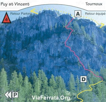
Via Ferrata de Tournoux, Puy St-Vincent, Hautes Alpes
| Passerelle | Pont de bois | Echelle | Tyrolienne |
| 0 | 0 | 0 | 0 |
Caractéristiques
Accessible aux débutants très bien accompagnés. Aérienne, elle propose quelques passages athlétiques mais assez courts.
La montée présente quelques passages athlétiques mais ils sont courts. Cette via est un circuit montée/descente. Le tout pour le même prix !
 Conseils ViaFerrata
La via est à l'ombre, ce qui est chouette durant les fortes chaleurs en été. Cependant, prends un truc anti-moustique ou du Tégarome (c'est un produit qui calme les piqures d'insectes. Comme c'est un produit naturel, bon-marché, qui fonctionne super bien, les entreprises chimiques l'ont interdit en Suisse).
Prends une petite laine car elle située au nord, donc c’est pas ici que tu va bronzer
Cotation
| Physique | 2 |
| Gaz | 1 |
| Type | 1 |
| Technique | Haute-Montagne: 1 |
| Evaluation | Peu Difficile |
Information
Office du tourisme de Puit-St-Vincent
 Longueur et Altitude
Dénivelé : 180 m.
Départ : 1750 m.
Orientation : Nord.
Roche : calcaire.
Longueur de la Via : 600 m.
Coordonnée GPS
Période
Mai à octobre
Horaire
Accès: 10 minutes
Viaferrata : 1 heure 30.
Retour : 20 minutes
 Par la route
Venant du nord, autoroute jusqu'à Grenoble, puis col du Lautaret RN 91. Traverse Briançon en direction de Gap.
A l'Argentière La Bessée, tourne à droite direction Vallouise, Puy St Vincent est à 10 km.
Venant du Sud, autoroute jusqu'à la Saulce, puis direction Briançon RN 94.
A l'Argentière La Bessez, tourne à gauche, direction Vallouise, Puy St Vincent est à 10 Km.
 Par le Train ou le Bus
Gare de l'Argentière les Ecrins, à 10 km de Puy St Vincent. Voir avec la SNCF: horaires et tarifs.


 Accès
Accès
A Puy Saint Vincent 1'400, au dessus de la Vallouise, prends la route de la Pousterle, (qui devient non-goudronnée).
Parque avant le grand replat au col.
Ensuite, prends le sentier à droite qui se dirige vers Tournoux. La Via est indiquée par un panneau.
Via Ferrata
Elle est bien équipée et parfois aérienne avec de courts moments d'efforts intenses.
La première partie débute par un mur vertical athlétique et aérien avant d’arriver vers un sentier plein de verdure et une descente câblée.
Ensuite, quelques passages raides dans un nouveau mur bien raide pour te refaire une descente un instant après. Tu as l’occasion de voir une grotte, fais un vœux !
Un nouveau mur donne l'accès à une descente sur la droite et tu rejoins le pied de la falaise.
Au sommet, tu découvres un très beaux panoramas sur les Ecrins et la Vallouise
Retour
Du pied de la falaise rejoindre facilement le chemin principal en contrebas et remonter au col de La Pousterle.
 Où dormir
Regarde avec l'Office du Tourisme.
vidéo par Zebrprod, Youtube
Photos


