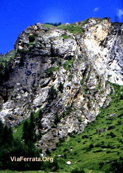
Via Ferrata les Bettières, Peisey Nancroix
| Passerelle | Pont de singe | Echelle | Tyrolienne |
| 1 | 1 | 0 | 0 |
Caractéristiques
Trois niveaux différents en trois parties avec des échappatoires entre les trois parties.
Pour toute la famille.
Accès au départ de la ferrata très rapide. Pont népalais impressionnant, quelques passages techniques qui demandent beaucoup de bras et de courage avec une sortie en dévers. Possible de prendre les échappatoires. La dernière partie est réservée aux chevronnés.
 Conseils ViaFerrata
C’est la grande foule durant l’été ! Vas-y de bonne heure le matin !
Si tu as le temps, fais le tour du Mont Pourri: Mt Pourri, Aiguille du St-Esprit, Dôme de la Sache, Gr 5.
Cotation
| Physique | L'Eperon des Croës: 1 Le Grand Pillier: 3 Le Sommet : 3 |
| Gaz | L'Eperon des Croës : 2 Le Grand Pillier : 3 Le Sommet : 3 |
| Type | Haute-Montagne: 2 |
| Technique | L'Eperon des Croës : 1 Le Grand Pillier : 1 Le Sommet : 1 |
| Evaluation | L'Eperon des Croës : Peu difficile - Initiation Le Grand Pillier : Difficile Le Sommet : Très Difficile |
Information
Office du Tourisme de Peysey-Vallandry
 Longueur & Altitudes
Départ Via-Ferrata: 1'556 m,
Arrivée Via-Ferrata 1'910 m.
Denivelé: 354 m
Longueur : 500 m
Coordonnée GPS
Latitude : 45.518932
Longitude : 6.802318
Période
Du 15 mai au 31 octobre
Horaire
l'Eperon des Croës
Accès ViaFerrata: 15 min
Via ferrata : 30 min
Retour : 20 min
Le Grand Pillier
Via ferrata: 45 minutes
Retour : 30 min
La Sortie
Via ferrata : 20min
Retour : 50 min
 Par la route
Rejoindre la vallée de la Tarentaise par l'autoroute Alberville, puis Moûtiers. Après Aime, prendre la direction de Landry. Monter les épingles dans la vallée de Peisey-Nancroix. Se garer en fond de vallée près du plan d'eau après le hameau des Lanches.
 Par le Train
Voir avec la SNCF pour les bus et train.


 Accès
Accès
Panneau d'information et fléchage en début de ferrata.
Via Ferrata
1er tronçon : l'éperon des Croës accessible aux enfants (PD), échappatoire en fin de tronçon. *Approche : 15 min
2è tronçon : Il débute par une verticale d'environ 50 mètres. Suivie par une arrête exposée et, continuant par une seconde verticale, pour s'achever sur le pont népalais. Second échappatoire permettant une redescente dans la vallée. *Approche : 0min depuis le 1er tronçon
3è tronçon : Grande dalle jaune surplombante plus sportive , retour par le plateau pour rattrapper le sentier "Les Lanches - Mont Pourri", ou par une sortie câblée à gauche qui descend directement dans la combe voisine et redescend en lacet. *Approche : 0min depuis le 2ème tronçon.
Cette dernière partie est très technique et difficile avec un dévers de 15 mètres. Il s'agit d'un surplomb impressionnant. Si tu n'as plus de force, prends l'échappatoire. La suite permet de rejoindre le sentier des Lanches – Le Mont Pourri.
Retour
Le retour est de toute beauté. Prends à gauche au sommet de la via. Suis les câbles et une échelle. Un sentier pentu te conduit directement au parking.
 Ou dormir
Refuge du Mont PourriRefuge du Mont Pourri: 2'380 m, au lieu-dit La Savolière. Accès par les Lanches
Photos


par viaferrataalpes, Youtube