Via Ferrata Tälli, Meiringen, Berne


 Passerelle  Pont de singe    Echelles   Tyrolienne 
0 0 5 0
  

Caractéristiques

Sur deux jours, la marche d'approche est un peu longue mais  de difficulté moyenne. La via comporte quelques passages aériens.


Astuces ViaFerrata

Prends la carte du coin et le matériel nécessaire pour passer deux bonnes journées en montagne.

A pratiquer uniquement par temps sûr, car il n'y a pas d'échappatoires.  Du névé persistant au départ, sur les vires plus en altitude et sur le sentier du retour de la face nord souvent au début de l'été (se munir le cas échéant de crampons et de piolets - mais à charge de savoir s'en servir).

Réserve ton lit avant de partir.


Cotation

 Physique   4
 Gaz  4
 Type    Haute-Montagne: 2  
 Technique  2
 Evaluation          Très Difficile


Information

Office du Tourisme

Téléférique du Tälli


Longueur et Altitude

1'500 m de dénivelé, 600 m de ferrata

Départ de la via: 2'067 m


Coordonnée GPS


Période

Juillet à début octobre


Horaire

1er jour: 550 m de dénivelé:  2h00 de marche
2ème jour: 1'000 m de dénivelé dont 600 m. de dénivelé. Ca devrait faire 6 h.


Par la route

Lyon-Genève, A 40; Genève-Lausanne N1, à Vevez prendre la direction Berne, Bâle N12;
-> A berne, prends la direction Interlaken N6,
-> à Interlaken en route pour Méringen-Furen.


Par le Train

En car postal de Meiringen à Gadmen. Contacte les CFF , pour les horaires et les tarifs


Accès

De Furen (1149 m) sur la route de la station inférieure du téléphérique Tälli (1171 m) jusqu'au restaurant Tälli ; pas d'arrêt officiel du car postal.

Renseignements auprès de la centrale électrique KWO à Innertkirchen, tél. 033 982 20 60.

A pied, pends brièvement le chemin d'accès de l'alpage Birchlaui (1'597 m) en remontant la pente peu boisée jusqu'au restaurant Tälli (1'716 m). Entreprendre la montée oblique en suivant le marquage blanc et bleu sous les parois abruptes du Tällistock jusqu'au départ de la via à l'Alpligerstock (2'067 m).
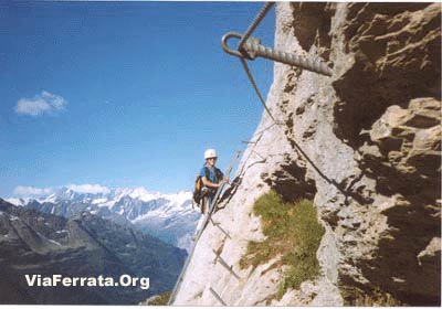
 

Via Ferrata

La ferrata commence par une échelle très raide qui conduit à une vire plane aérienne. Tu la suis à droite jusqu'à ce que l'équipement de sécurité indique à nouveau l'ascension.

La viaferrata prend de plus en plus d'altitude par des marches dans la roche, des dévers herbeux et des vires étroites ; banc en bois accueillant à un tiers de la via ferrata.

Suit une traversée assez exposée avant que la voie prenne la direction d'une vire en terrasse sur la partie supérieure de la paroi. Trois échelles verticales décalées gravissent ensuite sans problème un dièdre abrupt.  Reste bien concentré quand tu passes d'une échelle à l'autre… coups de cœur garantis… 

Une autre échelle métallique débouche de biais sur une vire herbeuse ascendante. Pour finir, on escalade l'arête par un éboulement jusqu'à la sortie.

Signe le livre d'or qui se situe dans la grotte.


Retour

Suivre le balisage blanc et bleu jusqu'à un petit cirque rocheux (névés fréquents en début d'été). Attention quelques névés pentus peuvent être glacés.

Compte un bonne heure, puis un sentier plus où moins à plat vers le SO durant une autre bonne heure avec la remontée vers le col du Satteli (2119m). Finalement redescendre vers la Tallihutte en 45 min.


Où dormir

Refuge de Tällihutte, 20 places ouvert de la mi juin à fin octobre.

Compte env. Frs. 20.-- par personne, Tél 033 975 14 10. Hors de Suisse ++ 41 33 975 14 10


Photos & Media


par Hans Howald, Youtube

Via Ferrata Tälli, Meiringen, Bern


   Footbridge      Monkey Bridge       Ladders         Zipline    
0 0 5 0


Features

 Takes two days, the approach is a bit long, but of mid-range difficulty. The via has several vertiginous sections.


ViaFerrata Tips and Tricks

Take the map of the area and all the gear you need to spend two long days in the mountains.

Only go if the weather is good and stable because there are no way outs. At the beginning of the summer snowfields remain at the start, on the ledges at higher altitudes and on the return path of the north face (equip yourself with crampons and an ice-axe if needed- but you must know how to use them).

Reserve a place at the hut before leaving.


Grade

 Strength  4
 Dizziness  4
 Type    High-Mountain: 2  
 Technics  2
 Evaluation          Very Difficult


Information

Office du Tourisme de Meiringen

Lifts: Téléférique du Tälli


Length and Altitude

1'500 m elevation gain, 600 m of which is the ferrata

Start of the via: 2'067 m


Time of Year

July to early October


Timing

1st day: 550 m of elevation gain:  2h00 of walking
2nd day: 1'000 m of elevation gain, 600 m of which is the via. This should total to 6 h.

By Car

Lyon-Geneva, A 40; Geneva-Lausanne N1, in Vevey go towards Bern, Basel/Bâle N12;
->In Bern, take N6 towards Interlaken,
-> in Interlaken go towards Méringen-Furen.


By Train

By bus from Meiringen to Gadmen. Contact the SBB for schedules and fares.


Access

From Furen (1149m) on the road from the bottom station of the Tälli lifts (1171 m) to the Tälli restaurant; there is no official bus stop.

Information from the electric power plant in Innertkirchen, tel. 033 982 20 60.

On foot, briefly follow the trail to access the Birchlaui pasture (1,597m) by going up the sparsly forested slope to the Tälli restaurant (1,716m). Take the sidelong uphill by following the white and blue markings under the steep walls of the Tällistock until you reach the start of the Alpligerstock via (2,067m).


Via Ferrata

The ferrata starts with a very steep ladder that leads to a flat vertiginous ledge. Follow it towards the right until the security equipment indicates a new ascent.

The via ferrata gains more and more altitude with some steps in the rock, grassy overhangs, and narrow ledges; there is a welcoming bench one third of the way up the via ferrata.

Follow a fairly exposed traverse before taking the path that leads to a kind of terace ledge on the upper part of the rock wall. Three staggered vertical ladders allow you to easily climb an abrupt dihedral. Stay focused when you go from one ladder to the next...your heart will skip a beat!

Another metallic ladder leads sideways to an ascending grassy ledge. To finish, we climb the ridge via a landslide to the exit.

Sign the golden book that is found in the cave.


Way Back

Follow the white and blue markings to a rocky cirque (snowfields often remain here at the beginning of summer).  Be careful as some of the steeper snowfields can be icy.


It will take a good hour, then, take a more or less flat path heading SW for another good hour, which includes the way back up towards the Satteli pass (2119m).
Lastly go back down towards the Tallihutte in about 45 min.

Where to Sleep

Refuge de Tällihutte, 20 spots available, open from mid-June to end of October.

Account for about 20.-- Frs. per person, Tel. 033 975 14 10. If calling from outside of Switzerland ++ 41 33 975 14 10


Media


by Hans Howald, Youtube